
Warwick & Warwickshire Maps: Free PDF Downloads (Tourist, Vintage & Road Maps)

LOOKING FOR DOWNLOADABLE WARWICKSHIRE MAPS AND GUIDES?
The historic county of Warwickshire lies at the very heart of England, a land immortalised by Shakespeare and steeped in medieval grandeur.
As one of Britain’s most culturally rich destinations, I’ve explored this captivating region numerous times – from the spires of Stratford-upon-Avon to Warwick’s towering castle – and have curated a selection of the finest free, downloadable PDF maps of Warwickshire.
PLAN YOUR TRIP WITH OUR FAVOURITE RESOURCES
→ Best Accommodation site: Booking.com
→ Book an Activity or a Day Tour here: Viator.com
→ Compare Bus, Coach & Train Prices here: Omio.com
→ Reserve your Rental Car here: DiscoverCars.com
Interactive Map of Warwickshire
This comprehensive Google map covers all key attractions across Warwickshire county:
★ Historic treasures including Warwick Castle and Shakespeare’s Birthplace
★ Scenic landscapes like the Cotswolds fringe and the River Avon’s tranquil waterways
★ Key towns (Warwick, Royal Leamington Spa, Rugby) alongside picturesque villages
★ Walking routes through timeless countryside and literary landmarks
✪ Get Your Shakespeares England Explorer Pass to Save More Money!
The Shakespeares England Explorer Pass gives you free access to 15 of the top things to do in Warwickshire, including Warwick Castle, Kenilworth Castle and others like the Butterfly Farm, Shakespeare’s Birthplace, Anne Hathaway’s Cottage, and more!
Passes start from £49 for 1 Day Pass, with the choice of 1, 2 or 3-Day Passes. Visiting just 2-3 locations will save you more than an individual ticket!
OS Explorer Map: X (OL45)
The gold standard for serious walking, this OS Explorer Map provides unmatched detail.


★ Trails – Cycle the Millennium Way or ride through Burton Dassett Hills Country Park
★ Terrain – Navigate the Cotswolds’ northern fringe and Feldon Valley’s rolling farmland
★ Nature – Key reserves like Ryton Wood Meadows (SSSI) and the River Avon’s wetlands
★ History – Marked routes pass Warwick Castle, Kenilworth’s ruins, and Saxon villages
→ Buy your Warwickshire Paper Map Here | → Try OS Maps App 50% Off
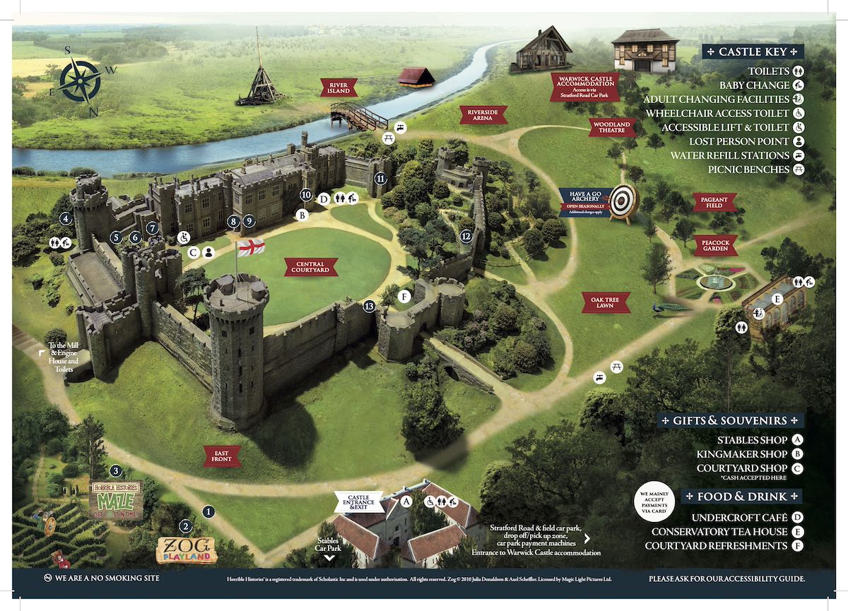
Warwick Castle Visitor’s Guide & Map
Warwick Castle’s visitor guide brochure – on page 1 are listings of daily actitivites, practical info, events and shows, and on page 2 is a detailed, aerial view of Warwick Castle with attraction listings, events and visitor facilities with illustrations of popular landmarks and points of interest around the castle grounds.
➤ Download the 2-page Warwick Castle PDF visitors guide here.

Warwick Castle consistently ranks the #1 Attraction in the West Midlands!
Kids can try their hand at archery, watch falconers command majestic birds of prey, or get lost in the Horrible Histories maze – one of the top outdoor mazes in the region. Plus jaw-dropping jousting tournaments
Get a 30% discount when you book your tickets in advance on the link below:
With so much rich history and family-friendly activities, I found Warwick Castle to be an unforgettable day out that’s both educational and entertaining for all ages. I’d highly recommend it for any visitor wanting to truly experience England’s medieval heritage.
Related: 10 Best Family Day Trips from Birmingham [2026]
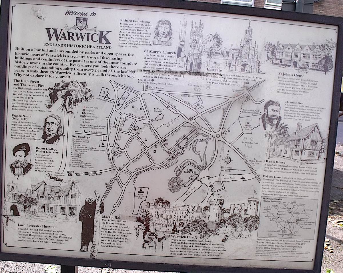
Tourist Map of Central Warwick (with Historical Info)
A modern tourist information stand of Warwick, with illustrations of notable historic figures, descriptions about them and the area’s history, and a street map highlighting key attractions like Warwick Castle, historic streets, and visitor amenities.
➤ Download the Tourist Map of Warwick PDF here.
★ Fancy a tour of Warwickshire’s popular attractions?
Here are some of our recommended guided tours of the most popular activities in Warwickshire:
➤ Warwick Castle, Stratford-upon-Avon and Oxford Day Trip – seamless guided tour with tickets and private car included
➤ Go on a hop-on, hop-off city sightseeing tour of Stratford-upon-Avon
See also: The 12 Best Places to Eat in Coventry
Central Warwick Road Map
Below is a simplified map of central Warwick, with its main roads and streets, car parks, green spaces, the river Avon, and landmarks/points of interest.
➤ Download the Central Warwick PDF road map here.

Driving through Warwickshire?
Driving is easily the best and most convenient way to get around the county, due to flexibility, speed and comfort.
If you don’t have your own car, your best bet is to hire a rental car – we recommend DiscoverCars for their transparency and positive reviews.
Accommodation Map: Best Places to Stay in Warwickshire
Finding the right accommodation ensures a comfortable base for exploring. Here are our top Warwickshire recommendations to suit all budget ranges:
◉ Luxury: The Plumb Townhouse (Entire Home) – a recently renovated, 2-bed holiday home right in the heart of Warwick, this place is usually fully-booked, so book in advance! – Superb 9.4☆
◉ Budget: Private Flat in Warwick (1-bed apartment) – excellent value, conveniently located and customers give this spot rave reviews! – Exceptional 9.7☆
Read: Discover the West Midlands with an English Heritage Membership
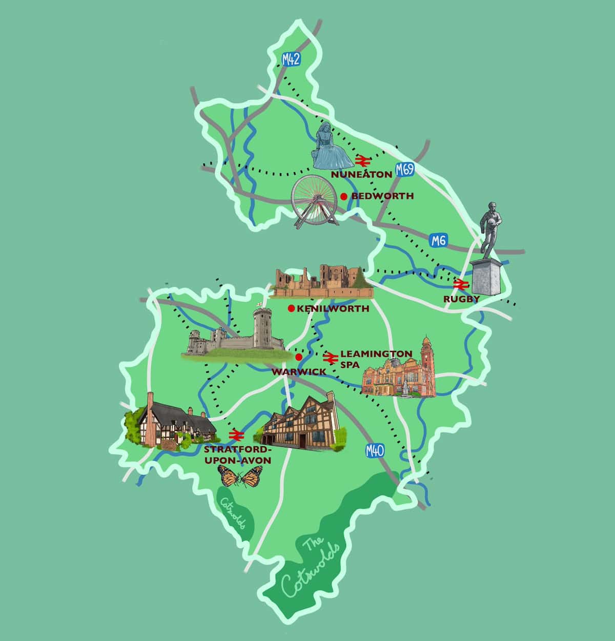
Illustrated Map of Warwickshire
Here’s an illustrated map of Warwickshire I created, depicting iconic landmarks like Warwick Castle, Shakespeare’s Birthplace, Anne Hathaway’s Cottage, the Butterfly Farm, Kenilworth Castle and statues of influential people, as well as main road routes, canals, railway lines, rivers countryside areas.
The North Warwickshire Line Rail Map
A railway map of the North Warwickshire Line, stretching from Birmingham to Stratford-upon-Avon via Henley-in-Arden.
➤ Download the The North Warwickhire Line Rail Map PDF here.

You may also like: Free PDF Maps of Coventry
Location Map of Warwickshire in England
Location map of Warwickshire (highlighted) in England, with neighbouring counties, motorways in blue, main A roads in green, and urban areas in grey highlighting major towns like Warwick, Stratford-upon-Avon, and Rugby. A small map of the UK sits in the top left corner highlighting Warwickshire’s position in red.
➤ You can download the Warwickshire County Location Map PDF here.

See also: The Best Time to Visit the West Midlands [Insiders Guide]
Warwickshire Locator Map in England
Here we have a map of England with county borders, and Warwickshire county highlighted in dark red (located in the heart of the country).
➤ You can download the Warwickshire Locator Map PDF here.

Vintage John Speed Map of Warwick
A historic 1610 John Speed map of central Warwick, detailing streets, churches, and landmarks like St. Hellen’s Church and the Castle.
➤ Download the Vintage John Speed Map of Warwick PDF here.

See also: The Wrekin – Shropshire’s Underrated Peak (+ Walking Maps)
1660s Map of Warwickshire by Richard Blome
This vintage map of Warwickshire dates back to the 1660s and was designed by cartographer Richard Blome for his Old Maps of England collection.

The map depicts the ancient county of Warwick with its earlier borders which included Coventry, as well as former place names that no longer exist today. The detail in the rivers, old roads and hills is immaculate.
➤ Download the Vintage Richard Blome Map of Warwick PDF here.

Historic Map of Stratford-upon-Avon
Next is a 1902 historic map of Stratford-upon-Avon, detailing streets that no longer exist (or are now built upon), with black and white photos of landmarks around the map, and the River Avon in Warwickshire. At the top is a portrait of the city’s most famous son, Shakespeare, flanked by the city’s crests.
➤ Download the Vintage PDF Stratford-upon-Avon Map here.

Vintage 1832 Map of Warwickshire
Below is an administrative map of Warwickshire county from 1832, with different shades of orange highlighted areas and regions within the county then known as the “historical hundreds”, with many former names of towns and villages (then known as “hundred divisions”) that are no longer in use today.
➤ Download the Vintage Warwickshire 1832 Map PDF here.

→ Related: more Maps posts:
Birmingham Maps [+ Travel Guides, Brochures]
Maps of The 6 Towns of Stoke-on-Trent [Free PDFs]
West Midlands County Maps (Free PDFs)
Ultimate Collection of Shropshire Maps (Free PDF Downloads)
15 Peak District Maps (Free Downloads)
Staffordshire Maps – Free Printable PDFs
Illustrated Map of the Cotswolds
Did you know that the northernmost part of the Cotswolds lies within Warwickshire? Here an illustrated map of the Cotswolds with its iconic towns and landmarks dotted around the map.

For more fun and interesting Cotswolds maps, read my guide: Maps of the Cotswolds, and you can also download them for free!
More Cotswolds posts:
16 Must-Visit Cotswolds Pubs
Ultimate 3-Day Cotswolds Itinerary (+ Hidden Gems & Driving Routes)
17 Charming Cotswolds Towns & Villages
Driving in the Cotswolds (Essential Tips + Best Routes)
★ Psst… Fancy a guided tour of the Cotswolds?
The best way to experience the highlights of the Cotswolds is by going on a guided tour led by an expert local, especially when you’re short on time. We recommend this customised, private full-day Cotswolds tour that gives you full control over the itinerary and route.
Further reading: Best Time to Explore the West Midlands
Satellite view of Warwickshire (Google Maps)
Here is an interactive satellite map of Warwickshire county on Google Maps. Scroll around the map and zoom in to see 3D views of the towns and villages, along with landmarks, nature spots and attractions which you can click on and discover more information about.
General Information about Warwickshire
Area: 763 square miles (1,975 km²)
Name origins: “Warwickshire” derives from “Wæringscīr” – the shire of Wæringa (the people of Weorg, meaning “dwellers by the weir or riverbank”).
Weather: 3°C lowest (winter), 23°C highest (summer)
Population: 590,600 (2022 estimate)
Highest Point: Ebrington Hill (261m, near the Cotswold escarpment)
Largest Lake: Draycote Water (650 acres)
Unique Features: Half-timbered Tudor buildings, red-brick Georgian architecture, and the legacy of William Shakespeare define the county.
Hidden gems: The Leicester Hospital Warwick (stunning medieval almshouse), Lord Leycester’s Guildhall Warwick (one of Britain’s finest surviving medieval structures), Compton Verney Art Gallery (Capability Brown-designed estate with world-class exhibitions).
Famous Residents (past and present): William Shakespeare (Stratford-upon-Avon), George Eliot (Nuneaton-born novelist), J.R.R. Tolkien (inspired by Warwick’s landscapes for The Lord of the Rings), Felicity Jones (Oscar-nominated actress, raised in Warwickshire), Claire Foy (The Crown actress, attended school in Warwickshire)
Further reading: Top Ten Paddle Boarding Spots in the West Midlands
Why is Warwickshire famous?
Warwickshire is renowned as Shakespeare’s birthplace, home to Stratford-upon-Avon and its Tudor heritage. The county boasts Warwick Castle, one of England’s finest medieval fortresses, and picturesque Cotswolds landscapes. It’s also celebrated for its literary connections (George Eliot), engineering history (Rugby’s industrial legacy), and quintessential English countryside, making it a cultural and historical gem.
What is the difference between Warwick and Warwickshire?
Warwick is a historic market town and the county town of Warwickshire, famed for its castle and medieval architecture. Warwickshire is the larger ceremonial county, encompassing towns like Stratford-upon-Avon, Rugby, and Leamington Spa. Think of Warwick as the heart of the region, while Warwickshire is the broader area with diverse urban and rural landscapes.
How many cities are there in Warwickshire?
Warwickshire has one official city: Coventry, though it’s now a metropolitan borough separate from the county council. Historically, Coventry and Lichfield (now in Staffordshire) were Warwickshire’s cities. Today, the county is known for its charming towns, with no officially designated cities within its current administrative boundaries—just rich history and vibrant communities.
Final Tips for Your Warwickshire Trip
✅ Buy a laminated OS Explorer Map if you plan serious walking – the weather can change quickly in this landscape.
✅ The OS Maps App (50% off here) provides excellent real-time directions across all trails with the location of most popular and hidden gem attractions
✅ Respect the wildlife – stick to marked trails and rely on the Countryside Code.
✅ Consider visiting in shoulder seasons (April-May or September-October) to avoid crowds.
✅ Combine your trip with visits to nearby regions like the Cotswolds or the Malvern Hills for extended exploration.
Read More:
18 Must-Do Family-Friendly Activities in Coventry
The Best Log Cabins with Hot Tubs near Birmingham


