
Cotswolds Maps: Interactive Maps, Travel Guides Free PDFs (+ HIDDEN GEMS Map)

LOOKING FOR DOWNLOADABLE COTSWOLDS MAPS AND GUIDES?
The majestic Cotswolds AONB begins in the south of the West Midlands, and covers the northwest of the south of England region.
One of my absolute favourite places in the UK, I’ve taken many a trip down south to this dreamy countryside paradise, and now I’ve compiled a collection of some of the best free, downloadable PDF maps of the Cotswolds.
Use these Cotswolds maps to help you plan your visit, find your way around, and discover the best villages and attractions. Once you’ve found your bearings, be sure to check out our guide to the Best Hotels in the Cotswolds and our list of 17 Charming Cotswolds Villages you won’t want to miss.
Staying in the Cotswolds? Here’s my Top Hotel Picks:
✳️ For First Timers: The Porch House, Stow (Fabulous 8.6) Sleep in history at England’s oldest inn, with cosy rooms and a fabulous pub. Perfect for exploring the classic villages & famous landmarks.

✳️ For a Romantic Escape: Lords of the Manor, Upper Slaughter (Exceptional 9.5) Stunning country house set in 8 acres of grounds. The ultimate luxury splurge in a picture-perfect village.

✳️ For Walkers & Explorers:
The Painswick (Superb 9.3) Stylish, vibrant hotel with stunning valley views. Step right onto the Cotswold Way from your doorstep.

Interactive Map of the Cotswolds
This comprehensive Google map covers all key attractions across the Cotswolds National Landscape:
★ Historic sites like Chedworth Roman Villa and Sudeley Castle
★ Wildlife reserves including the Cotswold Water Park
★ Population hubs (Cheltenham, Cirencester) and quieter villages
★ Walking routes between picturesque settlements
Ideal for planning your route, it highlights suitable stops for all types of visitors. Find a hotel near these top attractions using our interactive booking map.
→ Plan your perfect trip with my Ultimate 3-Day Cotswolds Itinerary: Hidden Gems & Most Efficient Routes
Why You Need a Specialised Cotswolds Map
The Cotswolds National Landscape spans 787 square miles of hills, valleys, and honey-stone villages between the West Midlands and southwest England.
This protected AONB-designated landscape features gentle wolds (rolling hills) that give the region its name. Patchy phone signals across rural areas means a dedicated map is essential for exploring properly.
With varying terrain – from the steep Cotswold Escarpment to water meadows along the River Windrush, an OS Explorer Map (like OL45 or OL17) reveals crucial details like bridleways, trails, and elevation changes that smartphone maps miss. There are also several Special Scientific Interest zones like Cleeve Hill’s limestone grasslands, home to rare wildlife.
Pro Tip: I always purchase a waterproof OS Explorer Map – like the one that helped me discover hidden wildflower meadows near Winchcombe last summer. For digital users, the OS Maps App offers real-time navigation across all trails.
→ Get 50% Off the OS Maps App Here ← | → Buy Paper OS Maps Here ←
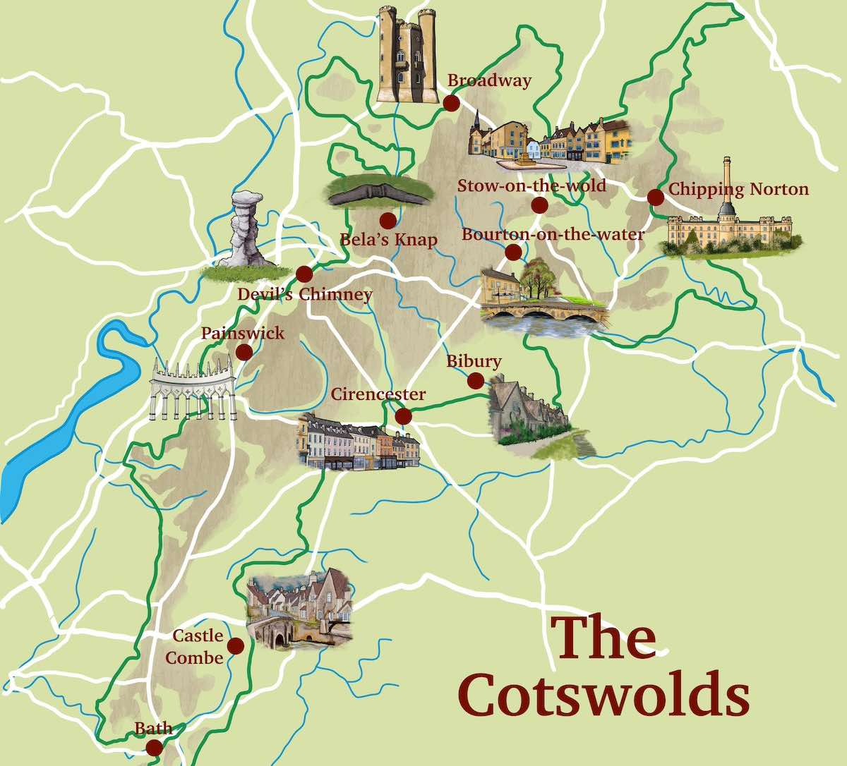
Illustrated Map: Cotswolds Icons & Landmarks
Here’s a detailed, illustrated visual map of the Cotswolds that I created.

Along with the main roads and canals that run through the region, it features the most iconic landmarks and places to visit in the Cotswolds, helping to give an artistic, visual overview of where they are located for your trip.
★ Psst… Fancy a guided tour of the Cotswolds?
The best way to experience the highlights of the Cotswolds is by going on a guided tour led by an expert local, especially when you’re short on time. We recommend this customised, private full-day Cotswolds tour that gives you full control over the itinerary and route.
Accommodation Map: Best Places to Stay in the Cotswolds
Finding the right accommodation ensures a comfortable base for exploring. Use the interactive map below to search for hotels and cottages by scrolling around and zooming in/out, and then click on a price marker to see more info about the place. Or, check out our hand-picked recommendations for some of the best-rated accommodation in the Cotswolds.
Not sure where to start? Here’s our recommended, highly-rated options perfect for a Cotswolds getaway:
◉ Luxury: The Fish Hotel (Broadway) – Featuring spa facilities, this family-friendly accommodation offers unique treehouse stays amidst the hills – Exceptional 9.5☆
◉ Budget: The Barrel Store (Cirencester) – Ideal for walkers tackling the Cotswold Way – Very Good 8.1☆
Not sure which part of the Cotswolds to stay in? Our 8 Best Hotels in the Cotswolds [+ Strategic Maps Guide] has got you covered. For a more unique option or a romantic escape, read our Best Cotswolds Log Cabins with Hot Tubs article.
★ Not staying overnight? No problem!
You can easily see the best of the Cotswolds on a guided day trip from London and other cities. Here are our recommended, popular day tours:
➤ Small group guided tour of the Cotswolds from London
➤ Day tour of the Cotswolds from Stratford-upon-Avon or Moreton-in-Marsh
➤ Small group, full-day tour of famous and hidden villages in the Cotswolds from Oxford
Related: 16 Historic, Family Friendly Pubs in the Cotswolds
Map of the Cotswold Way Trekking Route
Next we have a map of the Cotswold Way National Trail, a popular walking and trekking route that many walkers and hiking enthusiasts take to explore the region, starting from Chipping Campden in the north and ending at Bath in the south, passing through famous landmarks, attractions and viewpoints.
➤ Download the Cotswold Way PDF map here.

✨ From Map to Sky: A Unique Perspective
While your map is perfect for navigating the winding lanes, there’s no better way to truly appreciate the scale and beauty of the Cotswolds than from the air. Seeing the patchwork of green fields, golden stone villages, and rolling hills from above is an unforgettable experience.
➡️ Recommended Experience: For a truly breathtaking perspective, consider a Hot Air Balloon Flight over the Cotswolds. Drift silently above the scenery for a peaceful and panoramic view that a map can only hint at.
➡️ Alternatively, for a faster-paced aerial adventure, this highly-rated Cotswold Helicopter Tour offers a thrilling way to cover more ground and see iconic landmarks from a unique angle.
Can you walk from village to village in the Cotswolds?
Yes, walking between Cotswold villages is popular and often encouraged. The region is crisscrossed with numerous footpaths and bridleways, including the 102-mile Cotswold Way National Trail.
Many circular walks link multiple villages, allowing visitors to enjoy the scenic countryside while exploring different settlements. Always use marked paths and respect private property and the Countryside Code.
You may also like: 15+ Maps of the Peak District (Free PDF Downloads)
My Trusted Travel Gear for Cotswolds Trekking and Camping
Here’s a list of my most trusted travel gear that I’ve used in more than a decade of travel around the UK as well as abroad. I highly recommend these items for your visit to the Cotswolds – whether for walking, hiking or camping:
✅ Lifestraw Filter Water Bottle: Our go-to travel essential—it filters any water source to pure, clean drinking water while saving money and reducing plastic waste.
✅ Mens / Womens Patagonia Jackets: Versatile all-weather windbreakers that stay cool in summer and layer well in winter, combining style, comfort, and durability.
✅ Osprey Backpack: After a decade of testing, the 65L Osprey remains our top pick for reliability and longevity—worth the investment.
✅ Camping Essentials: Start with three basics—a budget-friendly tent (£99+), a sleeping bag, and a torch (£4+)—then add extras like a stove or chairs.
✅ Salomon Boots: Perfect for hikes or city walks, offering durability and comfort without bulk.
Related post: 17 Must-Visit Villages in the Cotswolds
The Cotswold Line Rail Map
This map shows the railway routes that crosses the Cotswolds region. Known as the Cotswold Line, the direct rail line starts in Oxford and ends at Hereford, with changes at stops along the route that take you to London, Birmingham, Bristol, Shrewsbury and Newport.
➤ Download the Cotswold Line Rail Map PDF here.

You may also like: Royal Market Towns in Staffordshire
✨ How to Explore the Villages, hassle-free
Connect the dots between picturesque but spread-out villages without the hassle of driving and parking. A guided walking tour lets you soak in the details you’d miss from a car. We recommend Macs Adventure for their highly-rated, detailed, customisable tours.
OS Explorer Map: The Cotswolds (OL45)
The gold standard for serious walking, this OS Explorer Map provides unmatched detail.

★ Trails suitable for cyclists and horse riders
★ Terrain gradients crucial for tackling the Cotswold Way
★ Nature reserves including Cleeve Common (Special Scientific Interest)
★ Historic sites for visitors marked along all major routes
→ Buy your OL45 Paper Map Here ← | → Try OS Maps App 50% Off ←
Driving through the Cotswolds?
Driving is easily the best and most convenient way to get around the Cotswolds, due to the large size of the region, and the poor public transport network in many of the rural towns and villages of the region.
If you don’t have your own car, your best bet is to hire a rental car – we recommend DiscoverCars for their transparency and positive reviews.
Our Driving in the Cotswolds Complete Guide covers everything you need to know.
The Cotswolds Locator Map in England
Here we have a map of England highlighting the Cotswolds Area of Outstanding Natural Beauty in dark green, located in the southwest of the country, spanning parts of Gloucestershire, Oxfordshire, Wiltshire, Somerset, Worcestershire, and Warwickshire.
➤ You can download the Cotswolds Locator Map PDF here.

Want to explore the Cotswolds’ ancient long barrows, Roman villas, and medieval ruins?
With an English Heritage Visitor Pass, you can enjoy unlimited access to 15+ historic sites across the Cotswolds National Landscape, including:
→ Belas Knap Long Barrow (a 5,000-year-old Neolithic tomb)
→ Cirencester Amphitheatre (one of Britain’s largest Roman arenas)
→ Hailes Abbey (haunting 13th-century Cistercian ruins)
→ Minster Lovell Hall (a picturesque 15th-century manor by the River Windrush)
Your OS Explorer Map covers all these sites plus trails linking them – perfect for combining history with scenic walks. Save 10% versus individual tickets and discover the Cotswolds’ layered past at your pace.

Tip: Pair your pass with an OS Explorer Map to navigate between sites like the Rollright Stones and Great Witcombe Roman Villa with ease.
Related post: Guide to English Heritage Membership (Pros + Cons)
Cotswolds Hidden Gems: Interactive Map
Use the map below to scroll around and zoom in on the best hidden gems around the Cotswolds. Click on the markers to reveal the name and location of the hidden gems!
Which is the best Cotswolds village to visit?
With so many beautiful settlements, it’s hard to choose just one! Bibury is arguably the most famous, with its picturesque Arlington Row cottages featured on countless postcards.
Castle Combe frequently tops polls as the prettiest, having starred in films like War Horse. For those interested in historic sites, Painswick offers stunning medieval architecture and the fascinating St. Mary’s Church with its 99 yew trees.
If you’re looking for suitable bases to explore, Stow-on-the-Wold covers excellent accommodation options and sits at the crossroads of several walking trails.
3-Day Cotswolds Itinerary: West Midlands to Bath
Day 1: Stratford-upon-Avon to Chipping Campden
Begin your journey in Shakespeare’s Stratford-upon-Avon (easily accessible from Birmingham). Spend the afternoon walking the first 3 miles of the Cotswold Way to Broadway Tower, enjoying panoramic views across the hills. The trails are moderately challenging but suitable for most visitors.


After picking up your OS Explorer Map, drive 30 minutes to Chipping Campden, the northern gateway to the Cotswolds National Landscape. Lose yourself in Chipping Campden’s breathtaking High Street, widely regarded as one of England’s most outstanding examples of medieval architecture.
Stay: Eight Bells Inn – a 14th-century pub with charming rooms and local ales.
Day 2: Bourton-on-the-Water to Stow-on-the-Wold
Morning:
Explore Bourton-on-the-Water‘s famous model village and the gardens of the Dragonfly Maze, one of the region’s best outdoor mazes.
★ Why not try a distillery tour with whisky and gin tasting?
The Cotswolds is famous for its whisky distilleries – learn what goes into the spirits, blend your own gin, and if you’re driving, you can even take your tastings away until you’re back at home / the hotel. Book your tour HERE:
Afternoon:
Hike 4 miles along the River Eye to Stow-on-the-Wold, stopping at picture-perfect Lower Slaughter (voted one of England’s prettiest villages). The route follows gentle trails through classic Cotswolds landscape.
Stay: The Old Stocks Inn – a luxury boutique hotel with spa facilities.


Day 3: Painswick to Bath
Morning:
Spend an hour or two walking around Painswick’s Rococo Gardens, one of the National Trust’s most unique properties.
Afternoon:
Drive along the Cotswold Escarpment to Bath, stopping at Westonbirt Arboretum if time allows. The course of this journey takes you through some of the region’s most spectacular landscape.
If you have more time, consider a romantic rowboat private picnic for two on the River Thames for something truly unique!
Vintage Road Map of the Cotswolds
Below is a vintage road map of the West Midlands and Cotswolds area from 1933, showing major towns like Birmingham, Worcester, Gloucester, and Oxford, with numbered roads connecting them.
➤ Download the Vintage PDF Cotswolds Road Map here.

Ordnance Survey Map of North Cotswolds
A detailed topographic map of the northern Cotswolds region from 1968. The ordnance survey map shows a complex network of roads, railways, towns, villages, and natural features including woodland and contour lines indicating elevation. Major towns of Cheltenham (in bottom left and Evesham (to left) are featured.
➤ Download the OS Northern Cotswolds Map PDF here.

What is the nicest area of Cotswolds?
While beauty is subjective, many consider the northern Cotswolds, particularly around Chipping Campden, Broadway, and Stow-on-the-Wold, to be the most scenic.
This area boasts quintessential Cotswold landscapes with rolling hills, honey-colored stone villages, and historic market towns. The Slaughters (Upper and Lower) are also frequently cited as among the most picturesque locations in the region.
See also: Maps of Warwick and Warwickshire (Free PDFs)
Vintage Geological Map of North Cotswolds
Now we have a historical sketch map of the North Cotswolds area from 1929, showing superficial deposits. The map includes topographical features, dry valleys, and an index of different geological deposits like alluvium, river gravel, and boulder clay.
➤ Download the Historical North Cotswolds Geological Map here.

Further reading: Top Free Activities & Attractions in the West Midlands
Satellite view of the Cotswolds (Google Maps)
Here is an interactive satellite map of the Cotswolds on Google Maps. You can scroll around the map and zoom in to see a 3D view of the towns and villages, along with landmarks, nature spots and attractions that you can click on and discover more information about.
How far apart are the villages in the Cotswolds?
Cotswold villages vary in their proximity, but many are within 2-5 miles of each other. For example, Upper Slaughter and Lower Slaughter are about a mile apart, while Bourton-on-the-Water and Stow-on-the-Wold are about 4 miles apart. The compact nature of the region means you can often visit several villages in a single day by car or on foot.
General Information about the Cotswolds
Area: 787 square miles (2,038km squared)
Name origins: “cot” and “wold”: “sheep enclosure in rolling hillsides“
Weather: 7C lowest (winter), 22C highest (summer)
Population: 90,800 (2022)
Highest Peak: Cleeve Hill (330m)
Largest Lake: Cleveland Lakes (330 acres)
Unique Features: Honey-coloured, chocolate-box Cotswold-stone cottages define the region
Hidden gems: The Oldest Chemist in England (Burford), the Police Museum and Courtroom (Tetbury), historic Water Wheels of Nailsworth
Famous Residents: King Charles and Camilla, The Beckhams, Kate Moss, Eddie Redmayne, Jay Z and Beyonce, Ellen DeGeneres
Plan Your Perfect Cotswolds Trip
Your maps are sorted! Now, use our detailed guides to build the rest of your itinerary:
➡️ Your Complete Itinerary: Follow our step-by-step guide for the perfect Cotswolds 3-Day Itinerary, designed to show you the very best of the region.
➡️ Where to Stay: Dive deep into our curated list of the 8 Best Hotels in the Cotswolds for every budget.
➡️ Find Your Cabin: Ready to book your escape? Explore our curated guide to the Best Log Cabins with Hot Tubs in the Cotswolds.
➡️ What to See: Discover the picture-perfect locations you’ll be visiting with our guide to 17 Charming Cotswolds Villages.
➡️ How to Get Around: Everything you need to know about Driving in the Cotswolds, including tips for narrow lanes and parking.
➡️ Where to Eat & Drink: Experience local flavour at the finest Cotswolds Pubs, from rustic inns to gastro pubs, and read our guide to the Best Afternoon Tea in the Cotswolds.
Use the maps on this page to locate all these incredible hotels, villages, and pubs during your trip!
What is the most interesting town in the Cotswolds?
Cirencester is often considered the most interesting town in the Cotswolds due to its rich history and amenities.
It was an important Roman town and now boasts the Corinium Museum, showcasing significant Roman artifacts.
The town’s market square, Abbey grounds, and the nearby Roman amphitheater add to its appeal.
However, towns like Chipping Campden, with its historic wool trade heritage, or Burford, with its medieval bridge and Tudor architecture, are also contenders.
What is the largest town in the Cotswolds?
Cheltenham is the largest town in the Cotswolds, with a population of around 117,000 (as of 2021).
Known for its Regency architecture, cultural festivals, stunning nature and famous racecourse, Cheltenham offers a blend of historic charm and modern amenities.
It’s situated on the western edge of the Cotswolds and serves as a major gateway to the region.
Which is the most beautiful part of the Cotswolds?
Most visitors find the northern section between Chipping Campden and Stow-on-the-Wold the most visually stunning.
This area features the quintessential Cotswolds landscape of rolling hills and honey-coloured stone villages.
The Cotswold Way offers breathtaking viewpoints, especially at Broadway Tower and Cleeve Hill (the highest point in the Cotswolds AONB).
For water features, the villages of the Coln Valley (like Bibury and Coln St Aldwyns) showcase beautiful riverside settings and nature spots. Buy an OS EXplorer Map to easily navigate the best trails.
Where exactly are the Cotswolds?
The Cotswolds National Landscape covers approximately 787 square miles across six counties in south-central England.
It stretches from just south of Stratford-upon-Avon in Warwickshire down to Bath in Somerset. The core area includes most of Gloucestershire and Oxfordshire, with parts extending into Wiltshire, Worcestershire, and Warwickshire.
The region is roughly 25 miles wide and 90 miles long, following the trails of the Cotswold Escarpment.
Major access points from the West Midlands include the A46 from Warwick and the A44 from Worcester, making it easily reachable for a weekend nature getaway.
What are the main towns in the Cotswolds?
The largest Cotswolds settlement is Cheltenham (population ~117,000), known for its Regency architecture and famous racecourse. Cirencester serves as the historic capital, with impressive Roman heritage at the Corinium Museum.
Market towns like Stow-on-the-Wold, Moreton-in-Marsh, and Tetbury offer charming high streets and regular farmers’ markets.
For transport hubs, Moreton-in-Marsh has direct train links to London, while Stroud provides excellent road connections.
The northern towns of Chipping Campden and Broadway are particularly popular with visitors for their well-preserved historic character and proximity to walking routes.
Download your FREE Cotswolds PDF Packing List Here
This list features our recommendations on what to pack for the Cotswolds in each season, with only the most trusted travel gear that we’ve used for years (plus some things that most tourists forget too!)

Final Tips for Your Cotswolds Trip
✅ Purchase a laminated OS Explorer Map if you plan serious walking – the weather can change quickly in this landscape.
✅ The OS Maps App (50% off here) provides excellent real-time directions across all trails with the location of most popular and hidden gem attractions
✅ Respect the wildlife – stick to marked trails and rely on the Countryside Code.
✅ Consider visiting in shoulder seasons (April-May or September-October) to avoid crowds.
✅ Combine your trip with visits to nearby regions like the Wales border or Oxford for extended exploration.
Related: more Maps posts:
Maps of the West Midlands (Free Download PDFs)
Birmingham Maps [+ Travel Guides, Brochures]
Maps of The 6 Towns of Stoke-on-Trent [Free PDFs]
Shrewsbury Maps [Free PDF Downloads]
Coventry Free Maps [Downloadable PDFs]
Collection of Shropshire Maps (Free PDF Downloads)
Staffordshire Maps [Free Downloadable PDFs]


![Stone, Staffordshire: Market Town History, Facts, Things to Do [Guide]](https://exploretheheartofengland.co.uk/wp-content/uploads/2024/05/stone-markets-2-768x512.jpg)
