West Midlands Maps: Interactive Guides, Best Routes & Hidden Gems (Free PDFs)

LOOKING FOR DOWNLOADABLE WEST MIDLANDS MAPS AND GUIDES?
As a proud local who has spent years exploring every corner of the West Midlands, I’m delighted to share this invaluable collection of FREE downloadable, printable PDF maps to help you navigate this dynamic region with ease.
Simply click on the link beneath each preview image to download your free maps and start exploring the heart of England like a local!
PLAN YOUR TRIP WITH OUR FAVOURITE RESOURCES
→ Best Accommodation site: Booking.com
→ Book an Activity or a Day Tour here: Viator.com
→ Compare Bus, Coach & Train Prices here: Omio.com
→ Reserve your Rental Car here: DiscoverCars.com
Interactive Map of the West Midlands
This comprehensive Google map covers all key attractions across the West Midlands county:
★ Historic sites like Chedworth Roman Villa and Sudeley Castle
★ Wildlife reserves including the Cotswold Water Park
★ Population hubs (Cheltenham, Cirencester) and quieter villages
★ Walking routes between picturesque settlements
See also: A Local’s Guide to the Black Country Slang & Dialect
West Midlands & Birmingham Metropolitan Area Map
This detailed administrative map provides a clear overview of the West Midlands region’s structure, showing how the metropolitan area encompasses major cities like Birmingham, Wolverhampton, and Coventry.
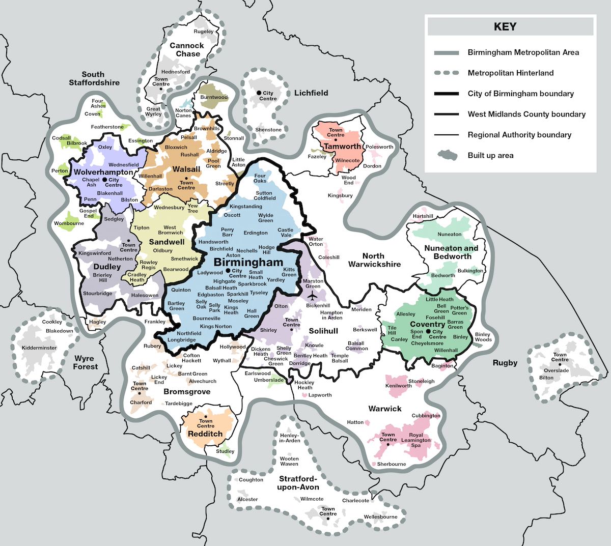
Colour-coding distinguishes between different administrative boundaries including the Birmingham Metropolitan Area, West Midlands County boundary, and various town centres, making it perfect for understanding the region’s political geography and planning cross-boundary travel.
➤ Download the West Midlands Metropolitan Area PDF map here.
West Midlands Tourist Attractions Map
This vibrant tourist-focused map showcases the West Midlands’ diverse attractions and cultural offerings, from Birmingham’s top attractions to the historic Black Country region.
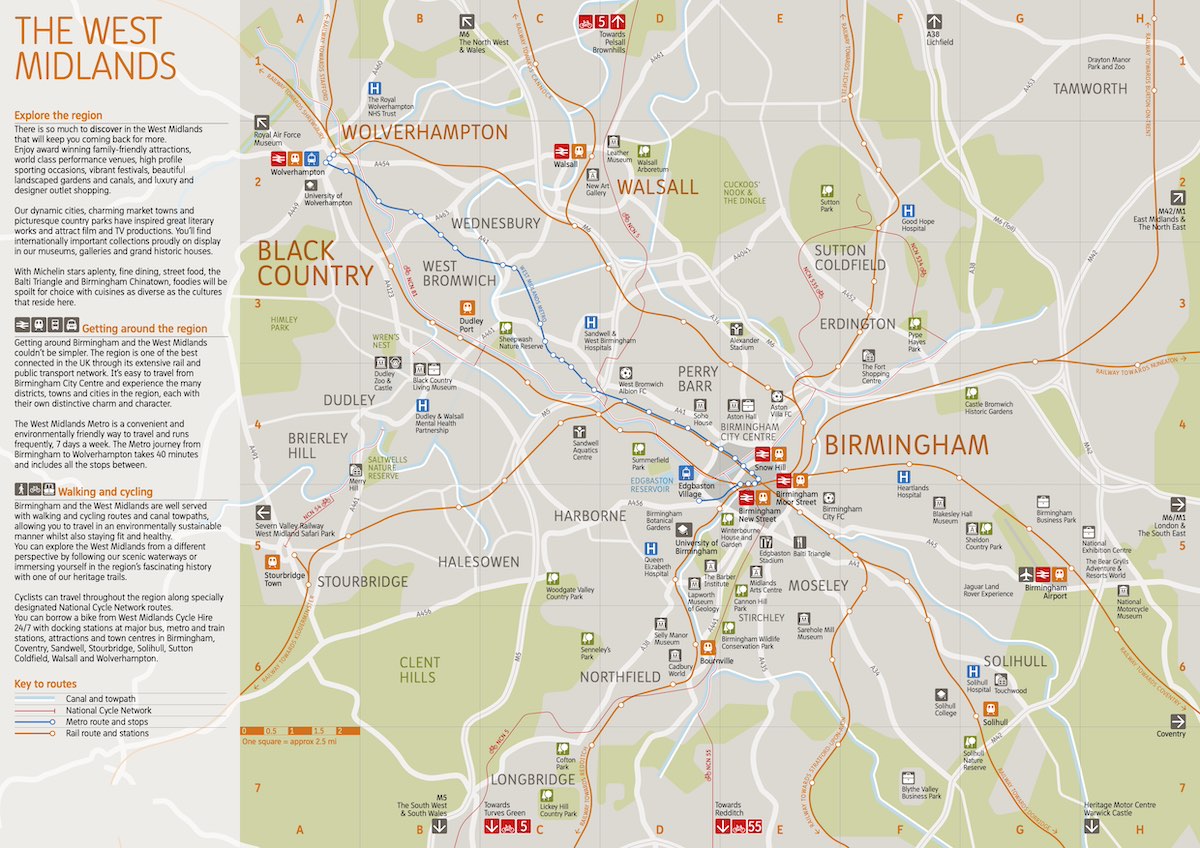
Intuitive icons and symbols mark museums, galleries, parks, and other visitor attractions, as well as transport connections, making it the perfect companion for exploring the region’s rich industrial heritage and modern cultural scene.
➤ Download the West Midlands tourist PDF map here.
★ Psst… Fancy a guided tour of Birmingham?
The best way to experience the West Midlands largest city, Birmingham, is by going on a guided tour led by an expert local, especially when you’re short on time. We recommend this highly-rated guided walking tour of Birmingham canals and heritage.
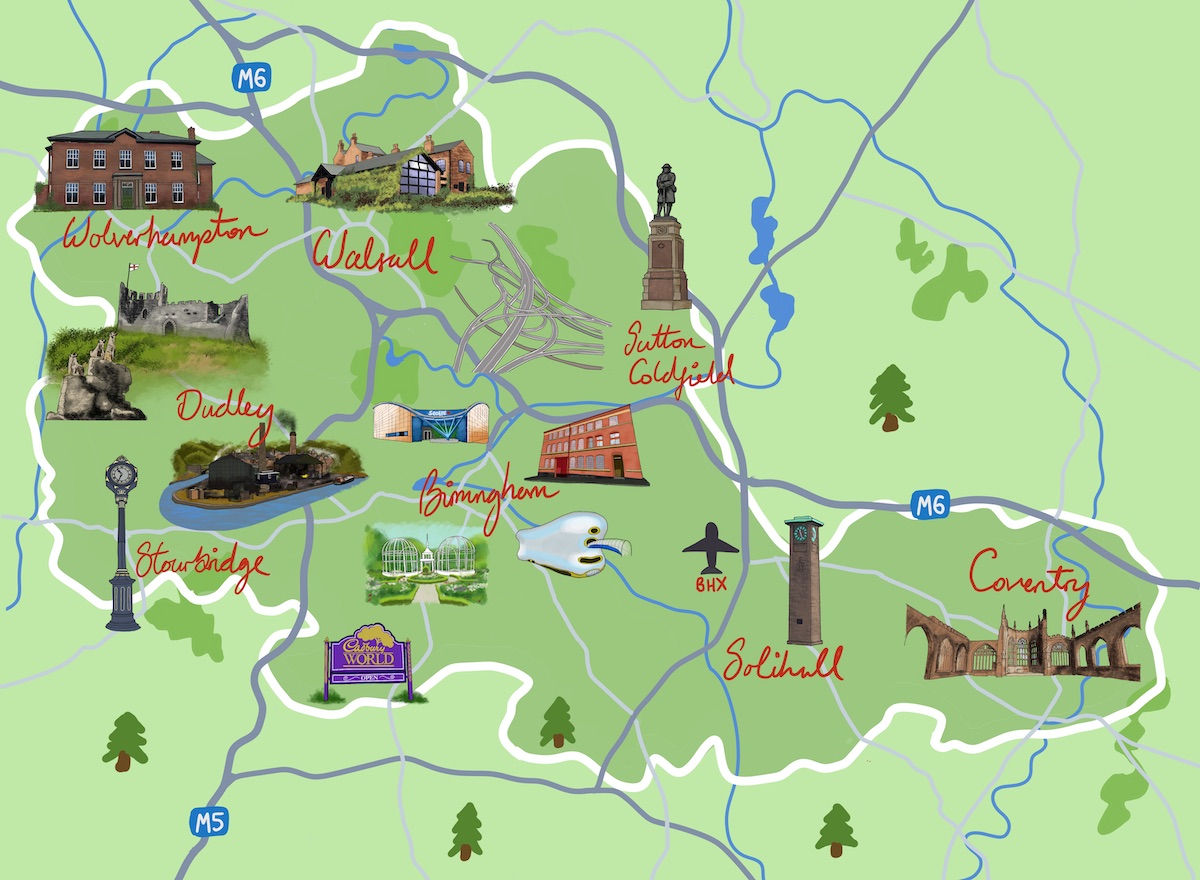
Illustration Map: West Midlands Icons & Landmarks
Here’s an illustrated visual map of the West Midlands that I created. It features some iconic attractions, cities, main roads, canals, and the main airport, Birmingham International (BHX), to help give a visual guide of the county in general.
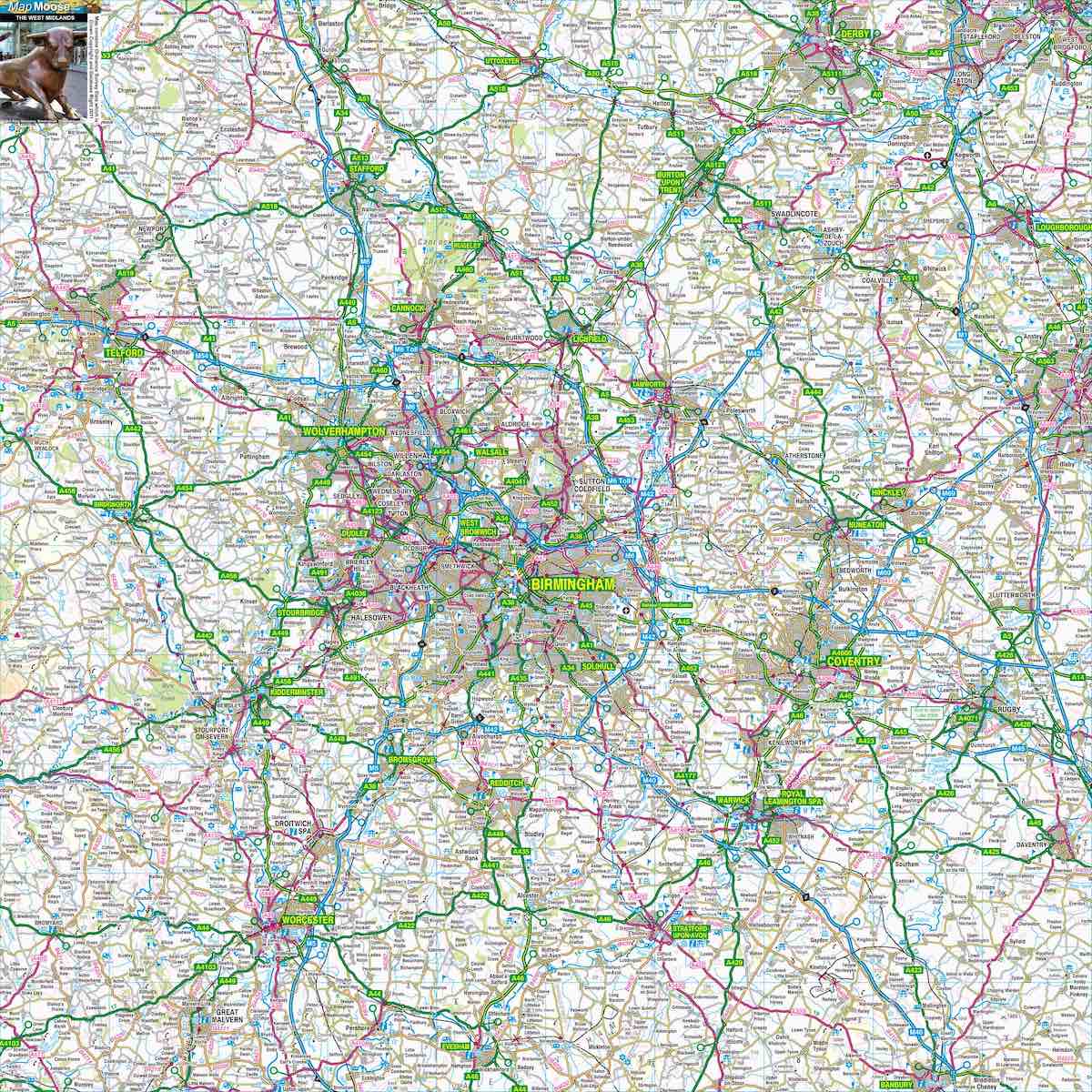
Detailed Road Map of West Midlands
This comprehensive road map provides the most detailed view of the West Midlands’ extensive road network, perfect for drivers and cyclists. It shows everything from major motorways like the M6 and M54 to local B-roads and minor routes, with clear topographical information that helps with navigation and route planning across the varied landscape of the region.
➤ Download the West Midlands Road Map PDF map here.
Driving through the West Midlands?
Driving is easily the best and most convenient way to get around the West Midlands, due to the large size of the region and for flexibility, speed and comfort.
If you don’t have your own car, your best bet is to hire a rental car – we recommend DiscoverCars for their transparency and positive reviews.
Read more: Best Time to Explore the West Midlands
West Midlands Railway Network Map
This official railway network map displays the complete West Midlands train system operated by West Midlands Railway, showing local services integrating with national rail connections.

Clear colour-coding distinguishes between different service types and operators, making it user-friendly for both local commuter services and longer-distance connections to London, Manchester, and other major UK destinations.
➤ Download the West Midlands Railway Network PDF map here.
Read more: 24 Fun Facts About The Black Country (a Yam Yam’s Guide)
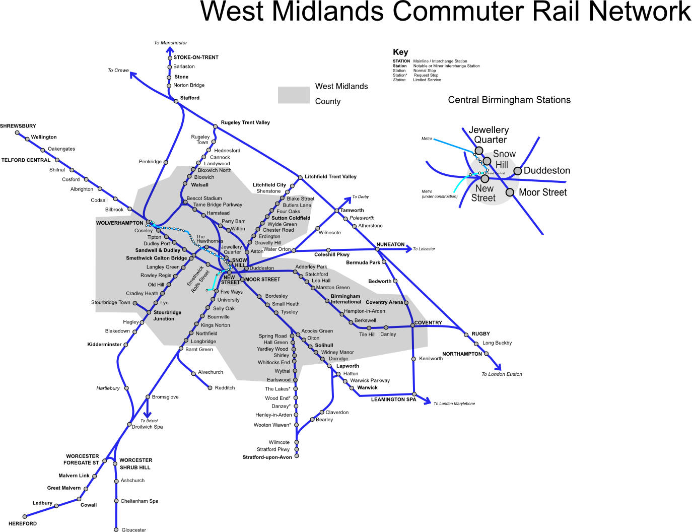
West Midlands Commuter Rail Network Map
This comprehensive rail network map displays the extensive commuter rail system that connects Birmingham’s city centre with surrounding towns and cities. The map clearly shows major interchange stations like Birmingham New Street and key routes extending to Wolverhampton, Coventry, and beyond.
➤ Download the West Midlands Commuter Rail Map PDF here.
You may also like: Best Kid-Friendly Days Out in the West Midlands
Accommodation Map: Best Places to Stay in the West Midlands
Finding the right accommodation ensures a comfortable base for exploring. Here are our top West Midlands recommendations to suit all budget ranges:
◉ Luxury: The Grand Hotel Birmingham (Family room) – £££ | Superb 9.1☆
◉ Budget: Dovehouse Farm, Birmingham (1-Bedroom house) – £ | Superb 9.0☆
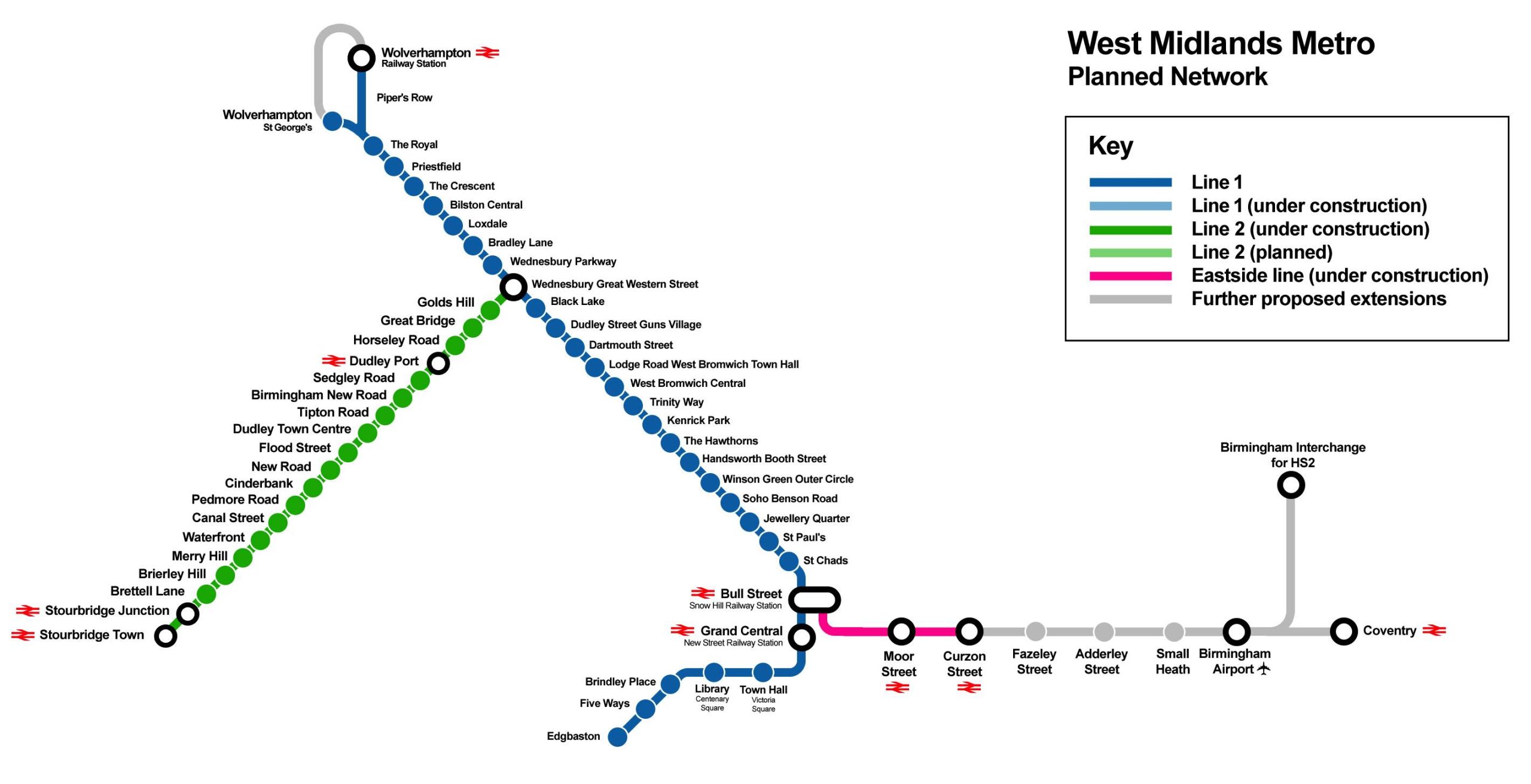
West Midlands Metro Planned Network
This forward-looking metro map shows the exciting expansion of the West Midlands Metro tram system, displaying both current services and planned extensions that will revolutionise public transport in the region.
➤ Download the West Midlands Metro planned network map PDF here.
You may also like: Royal Market Towns in Staffordshire
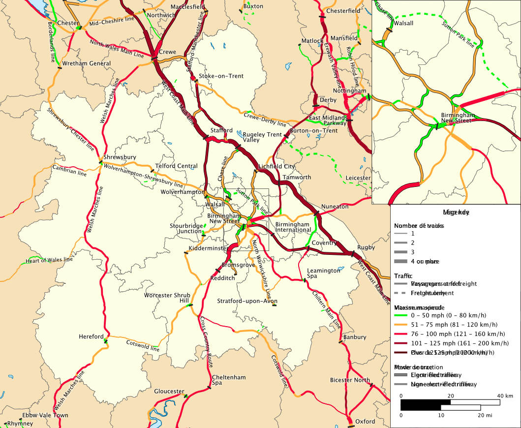
West Midlands Rail Network Speed and Capacity Map
This technical railway infrastructure map provides a detailed analysis of the West Midlands rail network’s capacity and speed capabilities, using colour-coding to identify the different types of services and track specifications.
The geographical map shows how high-speed main lines connect Birmingham to London and other major cities, while local services operate at varying speeds throughout the region.
➤ Download the West Midlands Rail Network and Capacity Map PDF here.
See also: Brummie Slang and Dialect: A Local’s Guide
Cross-City Line Route Map
This focused route map showcases the Cross-City Line, one of the West Midlands’ most important suburban rail services that cuts directly through Birmingham’s heart.
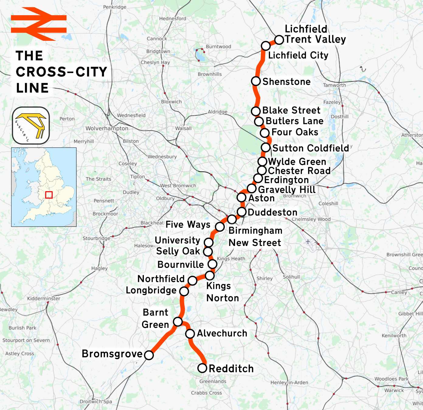
Running from Lichfield Trent Valley in the north to Redditch in the south, this vital transport artery connects numerous suburbs and passes through key destinations including Birmingham New Street.
➤ Download the Cross City Line Route Map here.
London Northwestern Railway Network Map
This comprehensive London Northwestern Railway network map shows the vital connections between Birmingham, Wolverhampton, and major UK destinations.
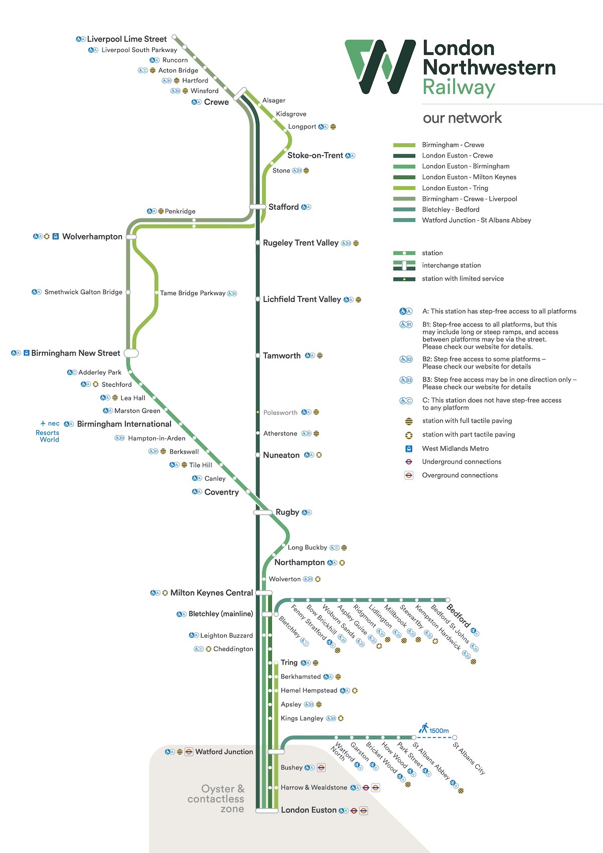
Clearly displayed is the main spine route from London Euston through Birmingham New Street to Wolverhampton, with important branches serving Stoke-on-Trent, Coventry, and Northampton.
➤ Download the London Northwestern Railway Map PDF here.
Read: Best Free Things to Do in the West Midlands
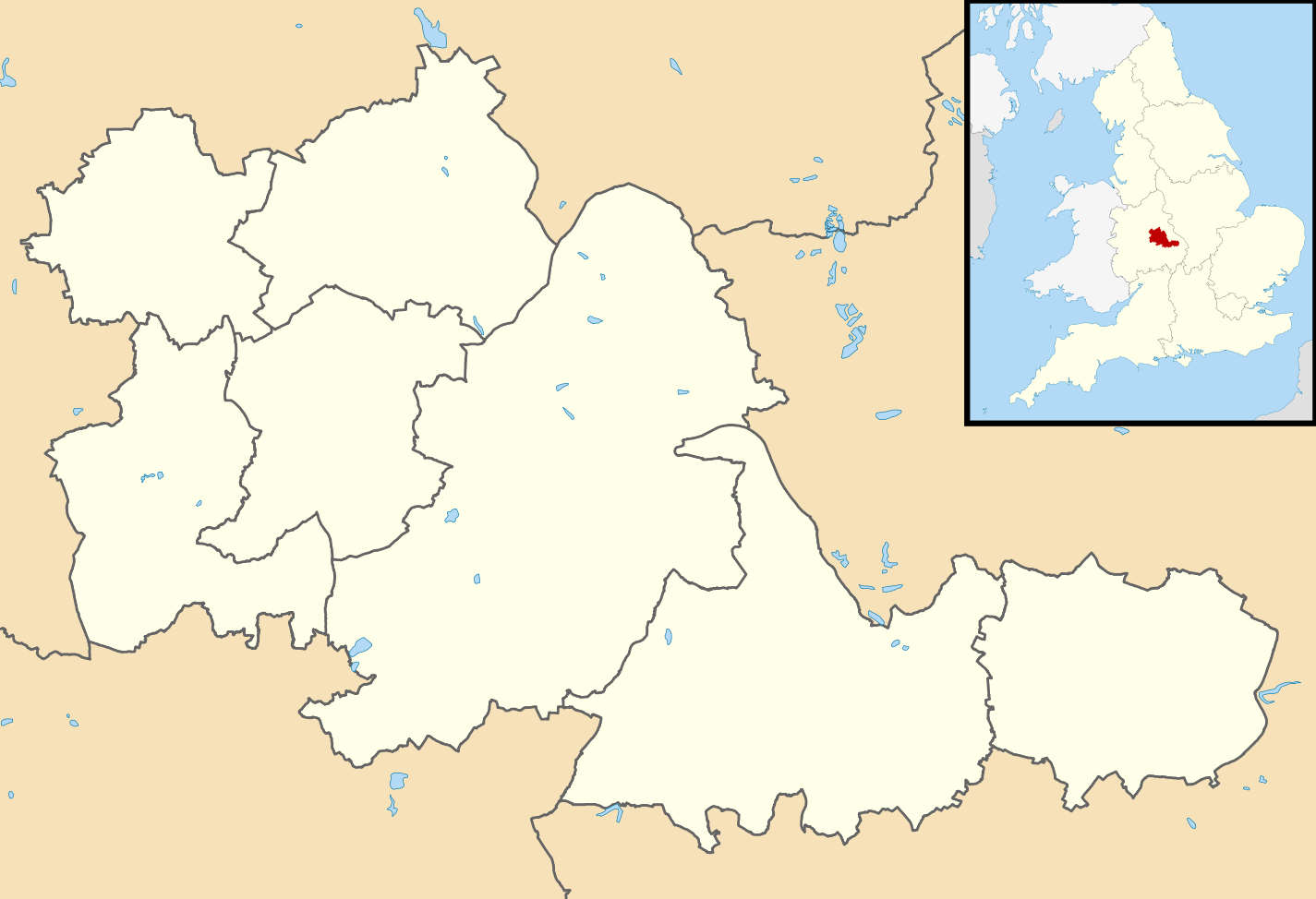
West Midlands Locator Map in England
Here we have a county borders map of the West Midlands (highlighted in cream on beige background), with a small map of England in the top right corner, with the West Midlands highlighted in red.
➤ You can download the West Midlands Locator Map PDF here.
Further reading: 47+ Interesting Facts About Birmingham
Satellite view of West Midlands County (Google Maps)
Here is an interactive satellite map of the West Midlands county on Google Maps. You can scroll around the map, go into street view, and zoom in to see a 3D view of the towns and villages along with landmarks, nature spots and attractions that you can click on and discover more information about.
General Information about the West Midlands
Area: 348 square miles (902 km squared)
Name origins:“western part of the central region of England“
Weather: 2C lowest (winter), 29C highest (summer)
Population: 2,919,600 (2022)
Highest Peak: Turners Hill (271m)
Largest Lake: Edgbaston Reservoir (70 acres)
Unique Features: Industrial heritage with Victorian red-brick architecture, canal networks, and the birthplace of the Industrial Revolution
Hidden gems: The Back to Backs (Birmingham’s last surviving court of back-to-back houses), Bantock House Museum (Wolverhampton), the Jewellery Quarter Discovery Centre (Birmingham)
Famous Residents: Ozzy Osbourne, Duran Duran, Judas Priest, Lenny Henry, Meera Syal, Frank Skinner, Adrian Chiles
Read more: 18 Best Things to See & Do in Coventry
What are the 7 districts of West Midlands?
The West Midlands metropolitan county comprises seven districts: Birmingham, Coventry, Dudley, Sandwell, Solihull, Walsall, and Wolverhampton. These boroughs form the core of the urban West Midlands, each with its own local council and distinct cultural identity.
What is the biggest town in the West Midlands?
Birmingham is the largest city and urban centre in the West Midlands, with a population of over 1.1 million. It serves as the economic and cultural hub of the region, known for its diverse industries, shopping districts, and vibrant arts scene.
What are the 14 local authorities of the West Midlands?
In addition to the seven metropolitan boroughs, the wider West Midlands region includes Herefordshire, Shropshire, Staffordshire, Stoke-on-Trent, Telford & Wrekin, Warwickshire, and Worcestershire. These authorities cover both urban and rural areas, extending beyond the immediate metropolitan county.
Related: more Maps posts:
Birmingham Maps [+ Travel Guides, Brochures]
Maps of The 6 Towns of Stoke-on-Trent [Free PDFs]
Shrewsbury Maps [Free PDF Downloads]
Coventry Free Maps (PDF Downloads)
Cotswolds Maps: Interactive & Downloadable Free PDFs
Collection of Shropshire Maps (Free PDFs)
Warwickshire and Warwick Maps (Free PDFs)
15+ Peak District Maps (Free PDF Downloads)
Staffordshire Maps (Free Downloadable PDFs)