Birmingham Maps: Brochures, Travel Guides, Interactive Map (Free PDFs)

LOOKING FOR DOWNLOADABLE BIRMINGHAM MAPS AND GUIDES?
As a longtime local having grown up in and around Birmingham, I’m here to share this valuable collection of FREE downloadable, printable PDF maps to help you plan your perfect visit, and guide you around all the exciting things that Birmingham has to offer.
The UK’s second-largest city packs an array of attractions, events, world-class food and landmarks, but is often overshadowed by London when it comes to visitors.
The city boasts everything from museums, historical landmarks, and beautiful parks, to shopping malls, chic cafes, family attractions, a chocolate factory, adventure activities, and a vibrant street art scene.
Simply click on the link beneath each preview image to download your free maps!
Accommodation Map: Find Your Perfect Birmingham Stay
Planning your visit to Birmingham starts with finding the right place to stay. Use the interactive map below to search for hotels across the city. Filter by price, reviews, and location to find the ideal base for exploring all the attractions you see on the maps further down this page.
How to use this map: Use the ‘+’ and ‘-‘ buttons to zoom in/out. Click on any of the hotel markers to see more details, photos, and prices. Clicking through will take you to Stay22 to complete your booking.
Prefer to search by area? The Bullring & Grand Central, the Jewellery Quarter, and Broad Street are all popular and well-connected areas for visitors. Here’s top recommendations:
◉ Luxury: The Exclusive Jacuzzi Apartment – in the heart of the city and is rated Exceptional 10/10☆
◉ Budget: Aparthotel Adagio (Digbeth) – a fabulous 1-bed apartment with everything you need – rated Superb 9.0☆
Interactive Map: Birmingham Highlights
Check out the interactive map below to see 13 of the most popular and iconic landmarks and attractions across Birmingham city, including museums, adventure attractions, historical sites and iconic landmarks.
The top 3 attractions in Birmingham are:
★ Cadbury World – the UK’s favourite chocolatier that has an indoor theme park, is especially great for kids. Book your tickets HERE:
★ National SEA LIFE Centre – home to over 2,000 sea creatures, features interactive displays and underwater tunnels for 360-degree views of the deep. Buy tickets HERE:
★ LEGOLAND Discovery Centre – perfect for kids aged 3-12, comes with 4D cinema and a miniature-scale version of Birmingham city built in Lego! Grab your tickets HERE:
Find a hotel near these top attractions using our interactive booking map at the top of this page.
Illustration Map: Birmingham Icons & Landmarks
Here’s an illustrated visual map of Birmingham city centre that I sketched. It features some iconic attractions, districts, main roads, and the canals that run through the heart of the city, to help give a visual guide of the city in general.

✳️ Fancy a guided tour of Birmingham’s Canals?
The best way to discover the city’s famous waterways and learn the history behind them is by going on a guided tour led by an expert local, especially when you’re short on time. We recommend this guided Birmingham walking tour.
You may also like: Downloadable & Interactive Maps of the Cotswolds [Free PDFs]
Birmingham Transport Maps
Two detailed maps of Birmingham’s public transport network, these well-designed maps are colour-coded and labelled, covering all the bus, train and tram routes in the city as well as in the larger West Midlands region.
You can download both maps in a single full, high-quality printable PDF here:
Driving around Birmingham and the West Midlands?
Although there’s a decent bus network in Brum, the best way to get around this region is by car, for flexibility, comfort and speed, and plenty of affordable and free parking spots.
If you don’t have your own, we recommend renting a car. Our go-to site is DiscoverCars – we’ve used them at home and abroad for years, and we like their transparency, great reviews, and easy-to-use site.
→ Dive deeper into local culture by learning about the fascinating divide between a Brummie and a Yam Yam here.
Birmingham Attractions Map
Detailed street map of the City Centre showing major districts and landmarks, areas highlighted include the Jewellery Quarter, Knowledge Quarter, City Centre, and surrounding districts.
Download the free PDF here:
Birmingham Waterways Map
Tourist map of Birmingham’s famous canal waterways, with various districts including Jewellery Quarter, St George, St Chad, Gunsmiths Quarter, Aston Triangle, Gas Street Basin, Eastside, Digbeth, Irish Quarter and more, plus info about the city’s canal heritage.
Download the free PDF here:

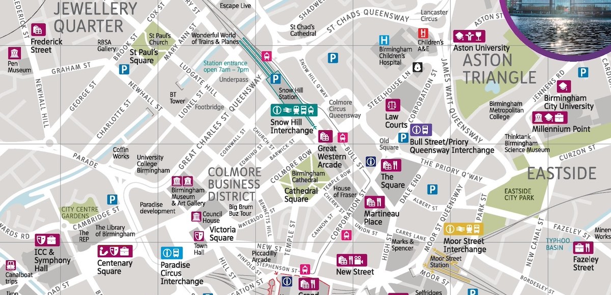
Birmingham City Centre Map
A detailed map with labels of all the roads as well as all the parking sites, bus and tram stops, and the train stations and stops.
Download the free PDF here:
Accommodation Map: Best Places to Stay in Birmingham
For the best way to find and book your stay, use our interactive hotel map at the top of this page. It shows real-time availability and prices from across the city.
If you’re looking for quick recommendations, here are two highly-rated options for different budgets:
◉ Luxury: The Exclusive Jacuzzi Apartment – in the heart of the city and is rated Exceptional 10/10☆
◉ Budget: Aparthotel Adagio (Digbeth) – a fabulous 1-bed apartment with everything you need – rated Superb 9.0☆
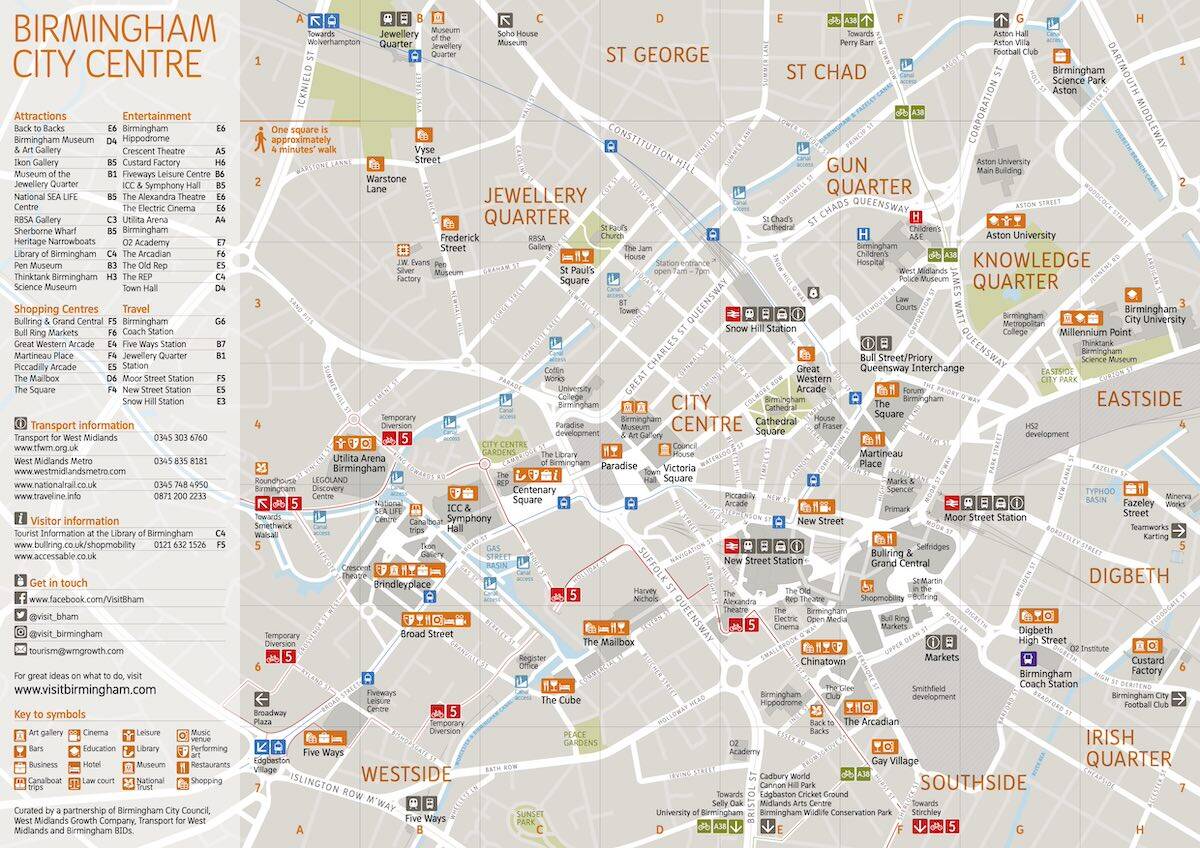
Birmingham Tourist Map
This map covers all the major landmarks and attractions in the centre of Birmingham, with street names, highlighted areas, and a legend chart coordinated with numbered points on the map.
Download the full printable PDF here:

✳️ Peaky Blinders: Birmingham Slogging Gangs Walking Tour with Edward Shelby
This popular immersive and educational walking tour takes you through the streets of 19th and 20th century Birmingham, stopping at historic pubs and landmarks, once operated by the notorious slogging gangs as seen in the Peaky Blinders hit tv show. Book your tickets HERE:
Birmingham Shopping Map
A useful map that details all the main shopping centres and malls across the city, highlighting some of the biggest brands and stores (like Primark, House of Fraser etc.) as well as various restaurants, cafes, cinemas, hotels, banks, plus toilet and baby-changing facilities.
Download the free PDF here:

Map of Top 10 Independent Restaurants in Birmingham (Our Picks)
Below are interactive google maps, this one is of the top 10 budget restaurants in Birmingham in yellow markers.
Birmingham’s Top 10 Independent Cafes on a Budget (Our Picks)
And here’s a map displaying the top 10 budget independent cafes around Birmingham.
✳️ Take a self-guided food tour of Birmingham
This self-guided food tour combines 5 of Birmingham’s best restaurants as you experience unique, authentic food concepts and signature dishes. Book your tickets HERE:
Birmingham Surroundings: Bus Map
A large map covering the entire bus and rail network in Birmingham and the surrounding areas of the West Midlands county.
Download the full, free PDF here:
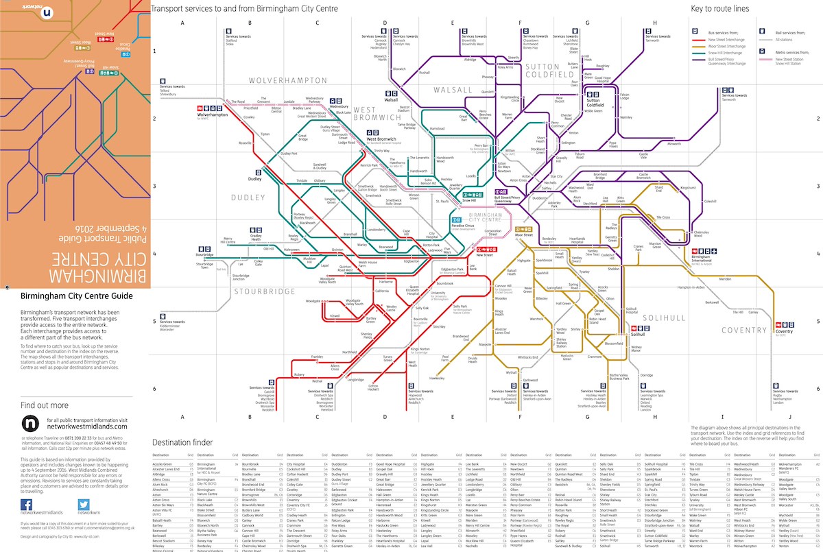
Birmingham Bus Services & Network Map #1
Next we have two, extremely useful and highly detailed maps with extensive information on the Bus network and bus services around Birmingham. The one below features the operator details and days of operation, specifically for the greater Birmingham area:
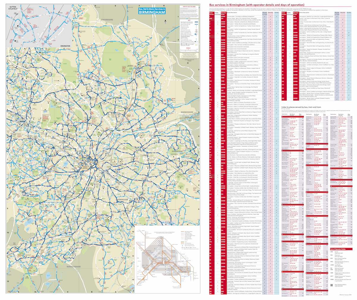
Download the free PDF here:
Birmingham Bus Network & Services Map #2
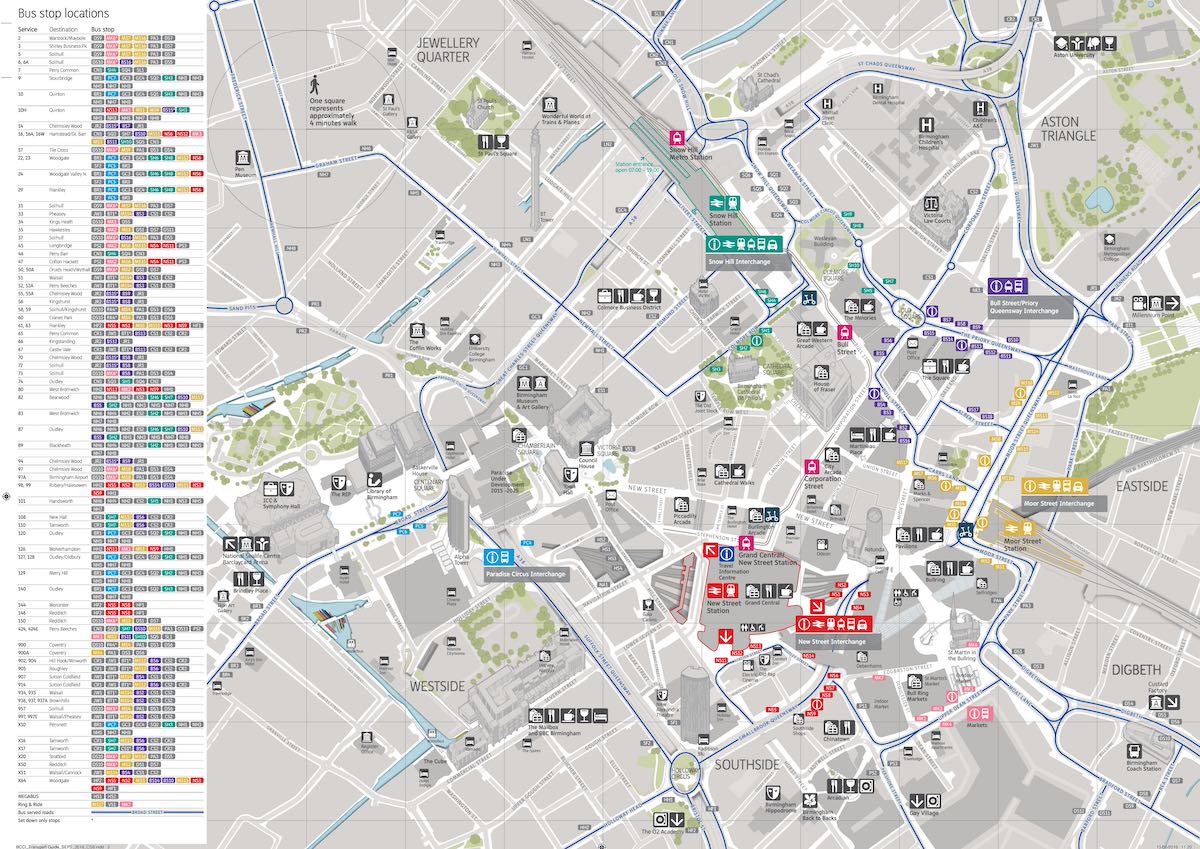
Here’s the second extensive bus services map for Birmingham updated June 2025, with the complete list of all the bus routes and bus numbers that serve the city centre specifically:
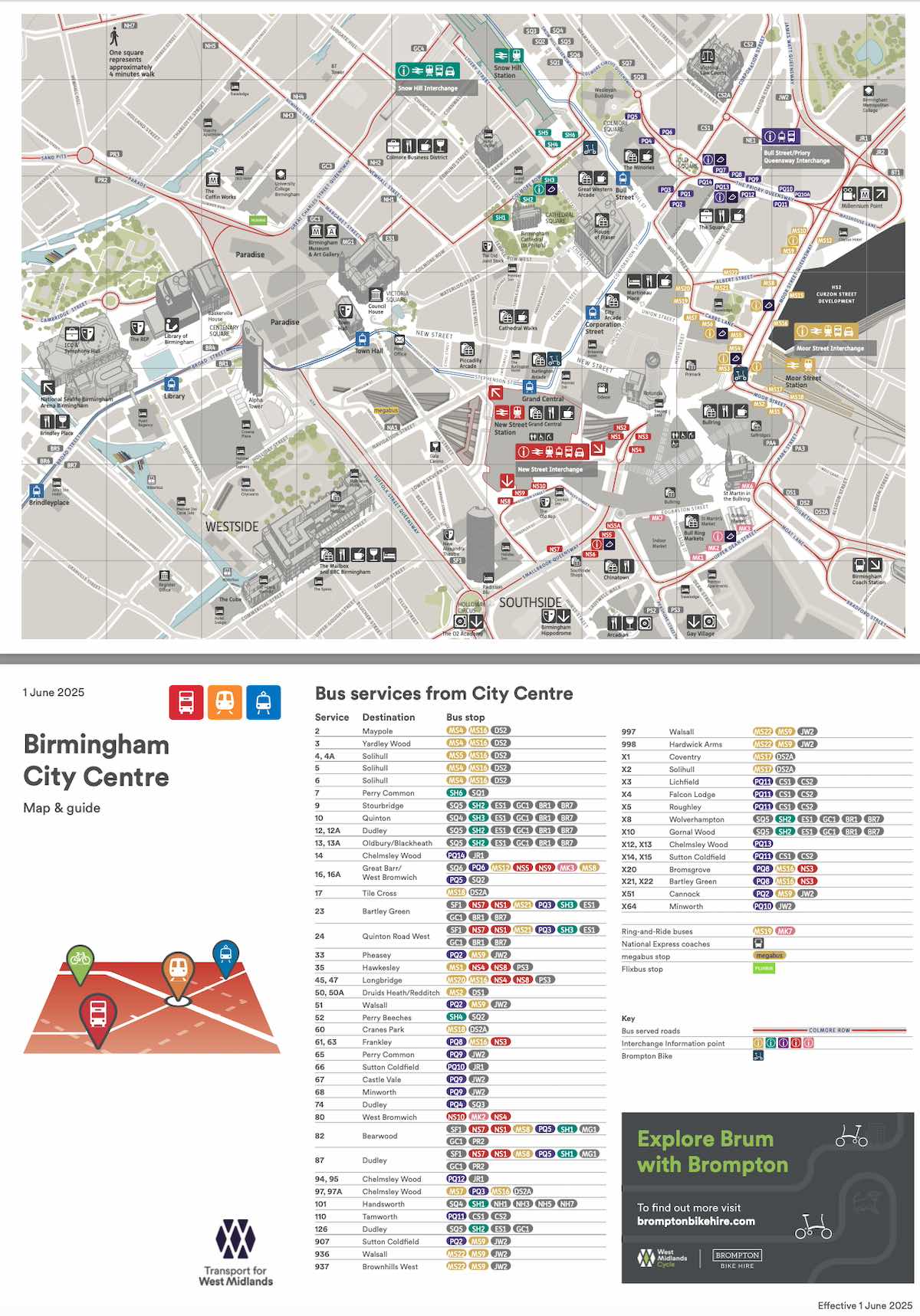
Download the free PDF here:
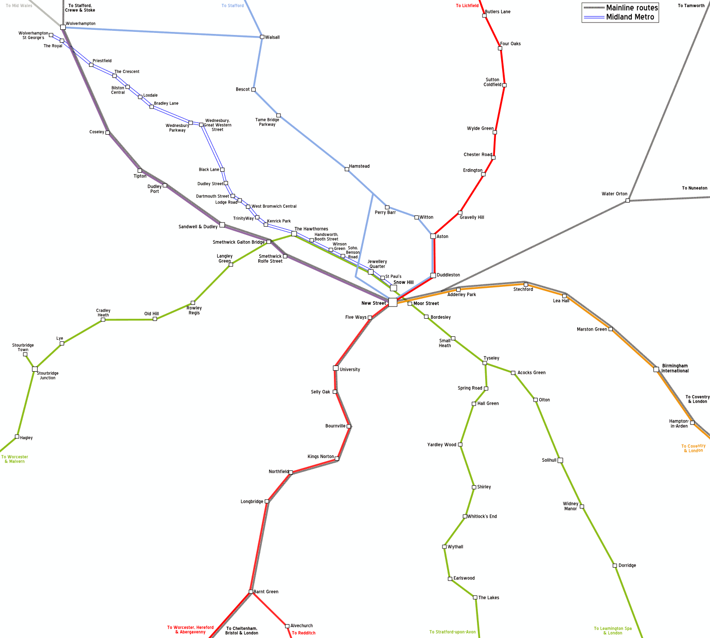
Birmingham Rail Network Map
A simple but easy-to-read and use rail network of Birmingham maps city centre, featuring colour-coded routes with labelled stops along each route.
Download the free PDF here:
→ More Birmingham posts:
The Best Time to Visit Birmingham
Free Things to Do in Birmingham
42 Fun Birmingham Facts
The Beginners Guide to Brummie Slang
7 Top Log Cabins with Hot Tubs near Birmingham
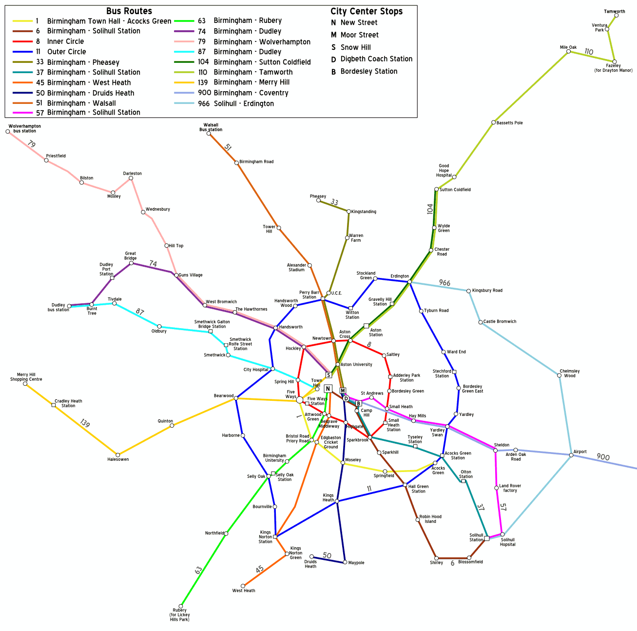
Birmingham Bus Network Map
Another simple and easy-to-read map of Birmingham’s bus network only, with coloured routes and labeled stops along the routes.
Download the free PDF here:

Satellite view of Birmingham (Google Maps)
Here is an interactive satellite map of Birmingham from Google Maps. You can scroll around the map and zoom in to see a 3D view of the city, along with landmarks and places of interest which you can click on and see more information about them.
General Information about Birmingham
Area: 267.8km squared
Weather: 8C (winter), 24C (summer)
Population: 1.1 million (3rd in UK)
Founded: 600AD, granted city status in 1889 by Queen Victoria
International Airport: Birmingham (BHX)
Train Stations: Birmingham New Street, Birmingham Snow Hill, Birmingham Moor Street, Birmingham International
Famous Residents: Ozzy Osbourne, Led Zeppelin, UB40, David Edgar (poet), Benjamin Zephaniah (writer)
Why is Birmingham so famous?
Birmingham gained fame as the heart of the Industrial Revolution. It’s known for its extensive canal network, diverse cultural scene, and iconic landmarks like the Bullring. The city’s innovation in manufacturing, particularly in the automotive and jewellery industries, has also contributed to its renown.
What is the oldest part of Birmingham?
The oldest part of Birmingham is the Digbeth area. It dates back to the 7th century and was mentioned in the Domesday Book of 1086. Digbeth was the original medieval centre of Birmingham and still retains some of its historic character, despite modern developments.
How many areas does Birmingham have?
Birmingham is divided into 69 wards for administrative purposes. These wards are grouped into 10 council constituencies. However, locals often refer to numerous neighbourhoods and districts within these official divisions, each with its own distinct character and community.
Is Birmingham built on a hill?
Birmingham isn’t built on a single hill, but rather on a series of hills. The city centre sits on a plateau about 500 feet above sea level. Notable hills include Lickey Hills, Clent Hills, and Barr Beacon, which offer panoramic views of the city and surrounding areas.
Related: more West Midlands Maps posts:
West Midlands County Maps
Coventry Free Maps [PDF Downloads]
Maps of The 6 Towns of Stoke-on-Trent [Free PDFs]
Shrewsbury Maps (Free PDF Downloads)
Maps of Shropshire County (PDF Downloads)
Warwickshire Maps (Free PDF Downloads)
15+ Maps of the Peak District (Free Downloads)
Staffordshire Maps – [Free Downloadable PDFs]