15 Peak District Maps: Guides, Best Routes & Interactive Trails (Free PDFs)

LOOKING FOR DOWNLOADABLE PEAK DISTRICT MAPS AND GUIDES?
As an avid rambler who has trekked the stunning peaks and valleys of this iconic national park, I’m thrilled to share this essential collection of FREE downloadable, printable PDF maps to help you conquer the breathtaking terrain of the UK’s first-ever national park with confidence.
Simply click on the link beneath each preview image to download your free maps and start exploring this majestic landscape like a true local!
PLAN YOUR TRIP WITH OUR FAVOURITE RESOURCES
→ Best Accommodation site: Booking.com
→ Book an Activity or a Day Tour here: Viator.com
→ Compare Bus, Coach & Train Prices here: Omio.com
→ Reserve your Rental Car here: DiscoverCars.com
Why You Need a Specialised Peak District Map
The Peak District National Park spans 555 square miles of rugged moorland, deep dales, and historic villages at the heart of northern England.
As Britain’s original national park, this protected landscape is split into the gritstone Dark Peak and the limestone White Peak. With unreliable mobile coverage across its remote areas, a dedicated map is vital for safe navigation.
The terrain is famously varied – from the wild peat plateaus of Kinder Scout to the gentle river valleys of Dovedale. An OS Explorer Map (like OL1 or OL24) reveals essential details like rights of way, cave systems, and steep contours that digital apps overlook. The park also contains numerous Special Scientific Interest sites, such as the rare alpine flora on the High Peak moors.
Pro Tip: I always carry a waterproof OS Explorer Map – it was a lifesaver for navigating the secret gritstone edges near Stanage last autumn. For digital hiking, the OS Maps App provides reliable offline navigation on all paths.
→ Get 50% Off the OS Maps App Here ← | → Buy Paper OS Maps Here ←
Interactive Map of the Peak District
This comprehensive Google map is your key to unlocking the entire Peak District National Park:
★ Historic sites like Chatsworth House and Peveril Castle
★ Nature reserves including the Dark Peak Moors and Dovedale National Nature Reserve
★ Walking hubs (Edale, Castleton) and serene stone-built villages
★ Iconic trails such as the Pennine Way and Monsal Trail
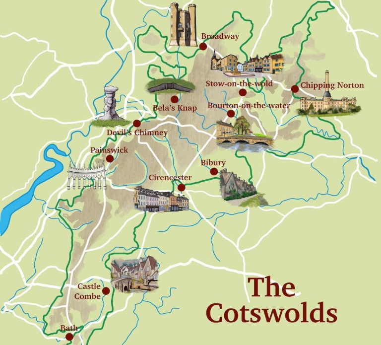
→ Related post: Cotswolds Maps: Free Printable PDF Guides, Maps, Walking Routes
OS Explorer Maps: The Peak District (OL1 & OL7)
The gold standard for serious walking, these OS Explorer Maps provide unmatched details – highly recommended for trekkers and visitors in general.

★ Trails suitable for cyclists and horse riders
★ Terrain gradients crucial for navigating dramatic dales and edges
★ Nature reserves including protected SSSI moorlands and meadows
★ Historic sites from castles to mines marked along all major routes
→ Buy your Paper Maps Here ← | → Try OS Maps App 50% Off ←
Peak District Landmarks Map
This simple map shows the main landmarks – including famous peaks and treks, of the Peak District, useful for memorising and getting familiar with the names of the places you intend to visit, and their proximity to each other.
➤ Download the Cotswold Way PDF map here.

★ Psst… Fancy a guided tour of the Peak District?
Sometimes an expert, guided tour by a knowledgeable local is an excellent way to see the highlights of this stunning region when you’re short on time. Here are our recommended tours & day trips:
Chatsworth & Peak District Small Group Tour (from Manchester)
Peak District eBike Tour (small group, 6 hours)
Hardwick Hall & the Beauty of the Peak District (full day tour, from Manchester)
Illustrated Map: Peak District Icons & Landmarks
Here’s a detailed, illustrated visual map of the Peak District that I created.
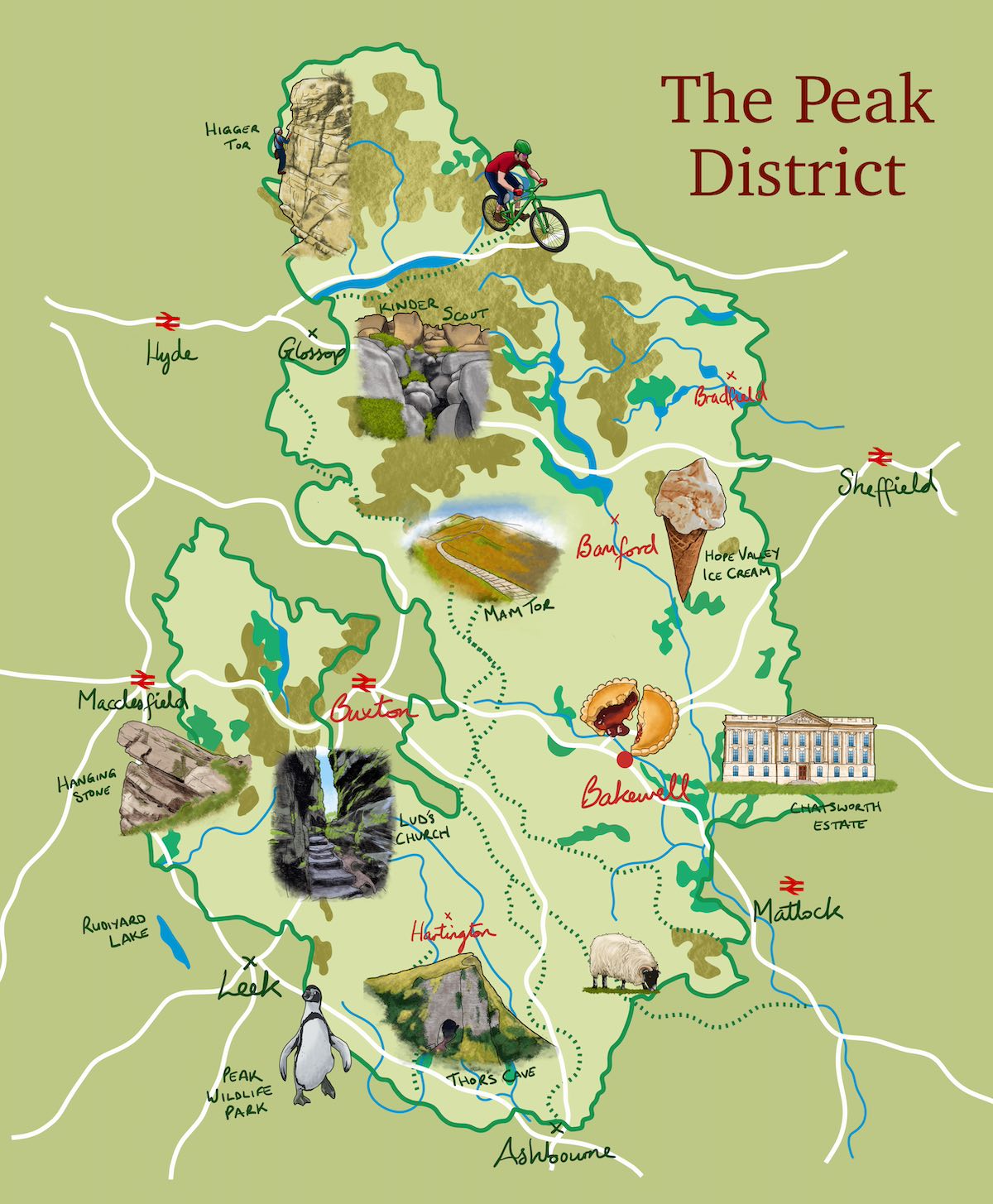
As well as the main roads and rivers that run through the region, this map features the most iconic landmarks, trekking routes and places to visit in the Peak District, helping to give an artistic, visual overview of where they are located for your trip.
→ You may also like: The Wrekin: Shropshire’s Tallest Peak (+ Free Walking Routes Maps)
PEAK DISTRICT OS TRAILS


My Trusted Travel Gear for Peak District Trekking and Camping
Here’s a list of my most trusted travel gear that I’ve used in more than a decade of travel around the UK as well as abroad. I highly recommend these items for your visit to the Peak District – whether for walking, hiking or camping:
✅ Lifestraw Filter Water Bottle: Our go-to travel essential—it filters any water source to pure, clean drinking water while saving money and reducing plastic waste.
✅ Mens / Womens Patagonia Jackets: Versatile all-weather windbreakers that stay cool in summer and layer well in winter, combining style, comfort, and durability.
✅ Osprey Backpack: After a decade of testing, the 65L Osprey remains our top pick for reliability and longevity—worth the investment.
✅ Camping Essentials: Start with three basics—a budget-friendly tent (£99+), a sleeping bag, and a torch (£4+)
✅ Salomon Boots: Perfect for hikes or village walks, offering durability and comfort without bulk.
Accommodation Map: Best Places to Stay in the Peak District
Finding the right accommodation ensures a comfortable base for exploring. Here are our top Peak District recommendations to suit all budget ranges:
◉ Luxury: The Merchant’s Yard (Tideswell) – Superior-deluxe room, this family-friendly accommodation comes with all the top-of-the-range amenities and is close to Chatsworth House and Buxton Opera House – Exceptional 9.5☆
◉ Budget: Olde House (Chesterfield) – Ideal for walkers tackling the Kinder Scout trail – Very Good 8.5☆
→ Related post: Staffordshire Maps: Free PDF Downloads
HERITAGE TRAIL MAPS
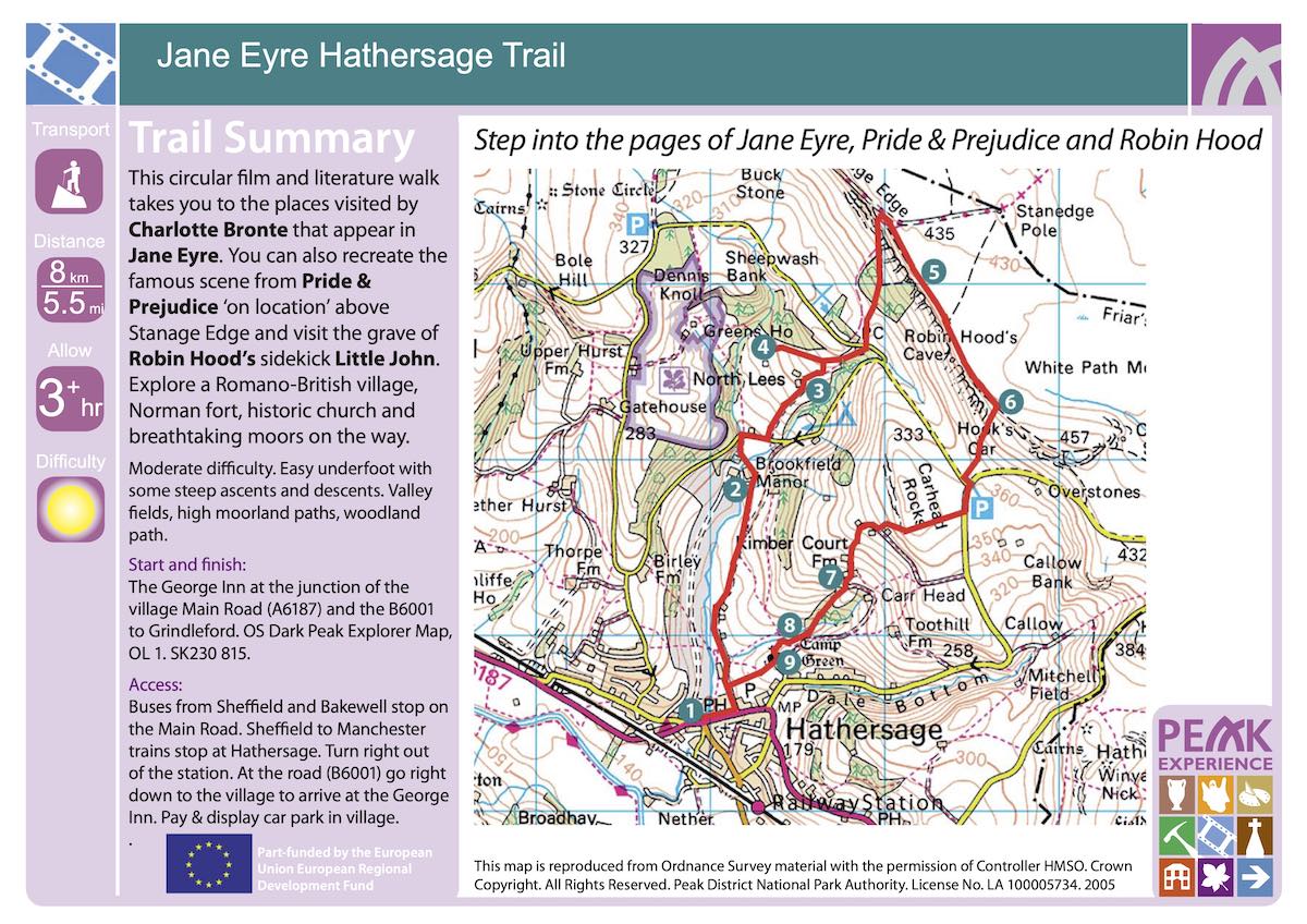
Jane Eyre Hathersage Trail Map
This OS-style close-up map and guide details the Jane Eyre Hathersage trail and all of the landmarks that allow the trekker to experience the fictional world of Jane Eyre’s works including Pride & Prejudice and Robin Hood.
➤ Download the Jane Eyre Hathersage Trail Map PDF here.
→ Related: West Midlands Maps, Interactive Guides, Hidden Gems (Free Downloads)
The Monsal Trail Map
This colourful illustrated map of the famous Monsal Trail also provides a detailed narrative, featuring interesting spots along the trail such as a huge limestone kiln, fossils, a Roman viaduct and more.
➤ Download the Monsal Trail PDF Map here.

White Peak Trails & Cycle Routes Map (Tissington Trail, High Peak Trail, Manifold Track & More)
The trekking and cycling routes of the iconic White Peak includes several popular trails such as the Manifold Track, the Tissington Trail, Route 54 and the High Peak Trail.

➤ Download the White Peak Trails & Cycle Routes Map PDF here.
➡️ Driving in the Peak District?
Driving is easily the best and most convenient way to get around the Peak District, due to the large size of the region, and the poor public transport network in many of the rural towns and villages of the region.
If you don’t have your own car, your best bet is to hire a rental car – we recommend DiscoverCars for their transparency and positive reviews.
→ Related post: Leek & Peak District, Staffordshire (Complete Guide)
Stoney Middleton Trail Map
This detailed guide features a simple trail map (below image) of the routes around the village of Stoney Middleton, showing photos of historic sites along the trails.
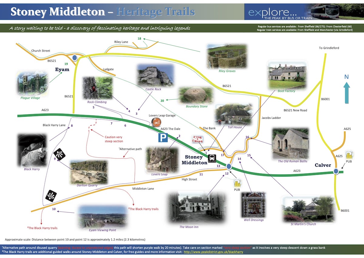
➤ Download the Stoney Middleton Trail Map & Guide PDF here.
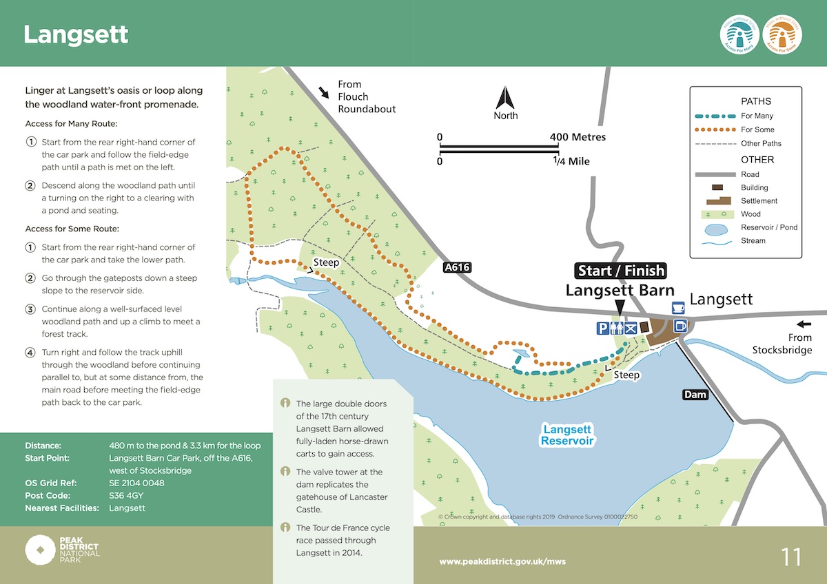
The Langsett Trail Map
This Miles Without Stiles map provides a clear and easy-to-use map of the Langsett trail with numbered directions, key of icons and some other useful bits of information.
➤ Download the Langsett Trail PDF Map here.
→ See also: Cannock Chase Forest, Staffordshire (Family-Friendly Activities)
Village Trails: Hartington to Pilsbury
This 6-page guide goes into detail on the Pilsbury Castle trail and all of its historic landmarks which are lettered on the map’s trail (see image below).
➤ Download the Hartington to Pilsbury PDF Guide here.

Village Trails: Hartington Village Map
This unique, 9-page guide is aimed at young children, telling a story of Hartington village and all its historic points of interest such as the Market Place (dating back to 1203 AD), Cheese Shop, Charles Cotton Hotel, and more. It also asks the reader questions and gives the reader a chance to write down their answers, findings and even drawings, perfect for keeping the young ones busy!
➤ Download the Hartington Village PDF Guide here.

→ Further reading: Your Ultimate 3-Day Cotswolds Trip (Itinerary)
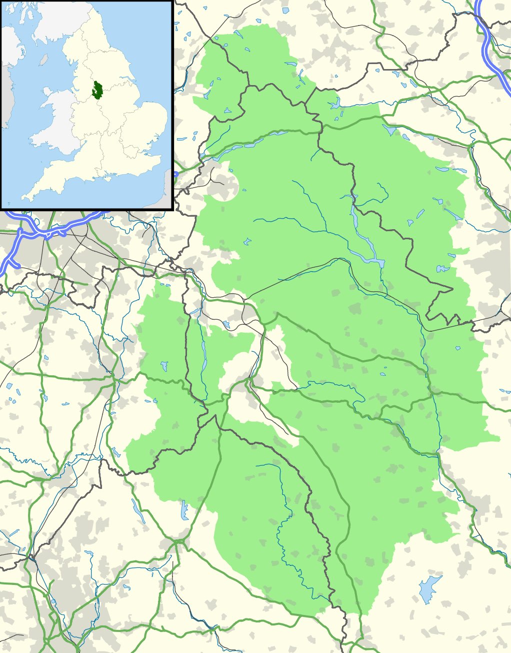
Peak District Locator Map in England
Here’s a map of the Peak District highlighted in light green with the county borders of Staffordshire, Derbyshire, Yorkshire and Cheshire, main roads, rivers, and urban areas highlighted in grey. In the top left corner is a small map of the UK with the Peak District region highlighted in dark green.
➤ You can download the Peak District Locator Map PDF here.
Related: more West Midlands Maps posts:
Birmingham Maps [+ Travel Guides, Brochures]
Warwickshire Maps (Free PDFs & Guides)
Shropshire Maps, Walking Routes & Guides (Free PDFs)
Maps of The 6 Towns of Stoke-on-Trent [Free PDFs]
Shrewsbury Maps [Free PDF Downloads]
Free PDF Maps of Coventry
Satellite view of the Peak District (Google Maps)
Below is an interactive satellite map of the Peak District on Google Maps. You can scroll around the map and zoom in to see a 3D view of the towns and villages, along with landmarks, nature spots and attractions that you can click on and discover more information about.
General Information about the Peak District
Area: 555 square miles (1,438km²)
Name origins: From the Old English ‘Peac’ or Celtic ‘Pek’, referring to the Pecsætan tribe.
Weather: 3°C lowest (winter), 19°C highest (summer)
Population: 38,000 (within the Park boundary)
Highest Peak: Kinder Scout (636m)
Largest Lake: Ladybower Reservoir (504 acres)
Unique Features: Split into the wild gritstone ‘Dark Peak’ and the lush limestone ‘White Peak’.
Hidden gems: The Plague Village of Eyam, the Blue John Cavern, the Nine Ladies Stone Circle.
Famous Residents: Vivienne Westwood, Joe Cocker, Beatrix Potter, Charlotte Brontë, Dave Berry, Diana Rigg, PD James (author)
Which is the prettiest part of Peak District?
This is subjective, but many are drawn to the dramatic limestone valleys of Dovedale and Monsal Dale for their rivers, stepping stones, and lush scenery. For awe-inspiring upland views, the wild, peat-covered plateaus of Kinder Scout and the iconic gritstone Stanage Edge are considered quintessentially beautiful and offer breathtaking panoramas.
Where does the Peak District start and end?
The Peak District’s boundaries are defined by the National Park, established in 1951. It spans parts of six counties but is primarily located in Derbyshire. The park stretches from the outskirts of Sheffield and Manchester in the north/north-west down to Ashbourne in the south, and from Bakewell eastwards towards Chesterfield.
How many days do you need in the Peak District?
A long weekend (3-4 days) allows you to explore a few key areas, such as a market town, a dale, and a moorland edge. To properly experience the diversity of both the Dark and White Peak, a full week is ideal. This gives ample time for several walks, exploring villages, and visiting historical sights without being rushed.
Which city is closest to Peak District?
Sheffield is arguably the closest major city, with its southwestern suburbs directly bordering the National Park. However, Manchester is also very close to the northern edges around Kinder Scout. Other nearby cities include Chesterfield to the east, Derby to the south, and Stoke-on-Trent to the west.
Final Tips for Your Peak District Trip
✅ Purchase a laminated OS Explorer Map if you plan serious walking – the weather can change quickly in this landscape.
✅ The OS Maps App (50% off here) provides excellent real-time directions across all trails with the location of most popular and hidden gem attractions
✅ Respect the wildlife – stick to marked trails and rely on the Countryside Code.
✅ Consider visiting in shoulder seasons (April-May or September-October) to avoid crowds.
✅ Combine your trip with visits to nearby regions like Yorkshire or Staffordshire for extended exploration.