FREE Staffordshire Maps: Printable PDFs for Walking & Exploring

LOOKING FOR DOWNLOADABLE STAFFORDSHIRE MAPS AND GUIDES?
As a seasoned explorer of this wonderfully diverse county I call home, I’m excited to present this essential collection of FREE downloadable, printable PDF maps to help you discover everything from Staffordshire‘s industrial heritage to its stunning rural landscapes with total ease.
Simply click on the link under each preview image to download your high-quality, free maps and uncover the unique character of Staffordshire like a true local!
PLAN YOUR TRIP WITH OUR FAVOURITE RESOURCES
→ Best Accommodation site: Booking.com
→ Book an Activity or a Day Tour here: Viator.com
→ Compare Bus, Coach & Train Prices here: Omio.com
→ Reserve your Rental Car here: DiscoverCars.com
Why You Need a Specialised Staffordshire Map
Staffordshire spans over 1,000 square miles of contrasting landscapes, from the industrial Potteries to the ancient woodland of Cannock Chase.
This diverse county contains an Area of Outstanding Natural Beauty and a rich industrial heritage. With unreliable phone signals in its rural heart, a dedicated map is essential for a proper exploration.
The terrain varies dramatically – from the rugged uplands of the Roaches to the tranquil canals of Stoke-on-Trent. An OS Explorer Map (like OL24 or 218) reveals crucial details like public footpaths, bridleways, and significant elevation changes that digital maps often miss. The county also contains several Sites of Special Scientific Interest, like the rare heathland of Cannock Chase, which is home to protected species.
Pro Tip: I always use a waterproof OS Explorer Map – it was crucial for finding hidden paths in the Manifold Valley last spring. For digital navigation, the OS Maps App provides excellent real-time tracking across the entire county.
→ Get 50% Off the OS Maps App Here ← | → Buy Paper OS Maps Here ←
Interactive Map of Staffordshire
This comprehensive Google map covers all key attractions across Staffordshire:
★ Historic sites like Stafford Castle and the ancient Tutbury Castle
★ Nature spots including the Cannock Chase Area of Outstanding Natural Beauty
★ Major towns (Stoke-on-Trent, Stafford) and charming market towns like Leek and Eccleshall
★ Scenic trails such as the Staffordshire Way and paths through the Manifold Valley
★ Grab tickets for Staffordshire’s top attraction Alton Towers: the UK’s BIGGEST Theme Park!
Staffordshire is home to the Number 1 theme park in the UK: Alton Towers – packed with the most exhilarating rollercoasters, water rides, and kids’ favourite Cbeebies Land – featuring Peter Rabbit, Octonaughts and more!
Use the link above to get tickets for £29 (down from £68 – saving you £39!)
→ Related post: How to Get to Alton Towers from Birmingham
OS Explorer Maps: X (OL24, 218, 219)
The gold standard for serious walking, grab one of these OS Explorer Maps providing unmatched detail.

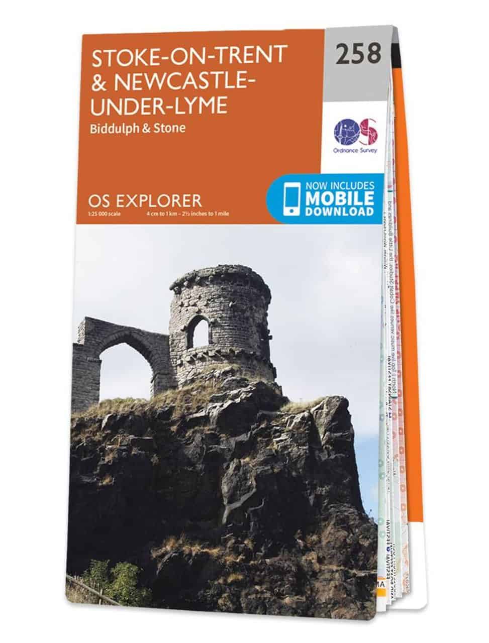
★ Trails suitable for cyclists and horse riders across Cannock Chase
★ Terrain gradients crucial for navigating the Roaches and the Staffordshire Way
★ Nature reserves including Doxey Marshes and Highgate Common
★ Historic sites from the Potteries’ factories to Boscobel House and the Royal Oak marked along all major routes
→ Buy your OL24 Paper Map Here ← | → Try OS Maps App 50% Off ←
Staffordshire Road Atlas
This highly-detailed and colourful road map of Staffordshire county shows major motorways, A-roads and B-roads with towns like Stoke-on-Trent, Burton, Tamworth and Stafford prominently featured, along with topographical details and comprehensive road network coverage.
➤ Download the Staffordshire county Atlas PDF here.

Driving through Staffordshire?
Driving is easily the best and most convenient way to get around the area, due to the large size of the region, and the poor public transport network in many of the rural towns and villages of the region.
If you don’t have your own car, your best bet is to hire a rental car – we recommend DiscoverCars for their transparency and positive reviews.
Illustrated Map: Staffordshire Icons & Landmarks
Here’s a detailed, illustrated visual map of Staffordshire that I created.

Along with the main roads, railways and canals that run through the region, it features the most iconic landmarks and places to visit in Staffordshire, giving an artistic, visual overview of where they are located for your trip.
My Trusted Travel Gear for Staffordshire Hiking and Camping
Here’s a list of my most trusted travel gear that I’ve used in more than a decade of travel around the UK as well as abroad. I highly recommend these items for your Staffordshire trips – whether for walking, hiking or camping:
✅ Lifestraw Filter Water Bottle: Our go-to travel essential filters any water source to pure, clean drinking water while saving money and reducing plastic waste.
✅ Mens / Womens Patagonia Jackets: Versatile all-weather windbreakers that stay cool in summer and layer well in winter, combining style, comfort, and durability.
✅ Osprey Backpack: After a decade of testing, the 65L Osprey remains our top pick for reliability and longevity—worth the investment.
✅ Camping Essentials: Start with three basics—a budget-friendly tent (£99+), a sleeping bag, and a torch (£4+) (add extras like a stove or chairs)
✅ Salomon Boots: Perfect for hikes or city walks, offering durability and comfort without bulk.
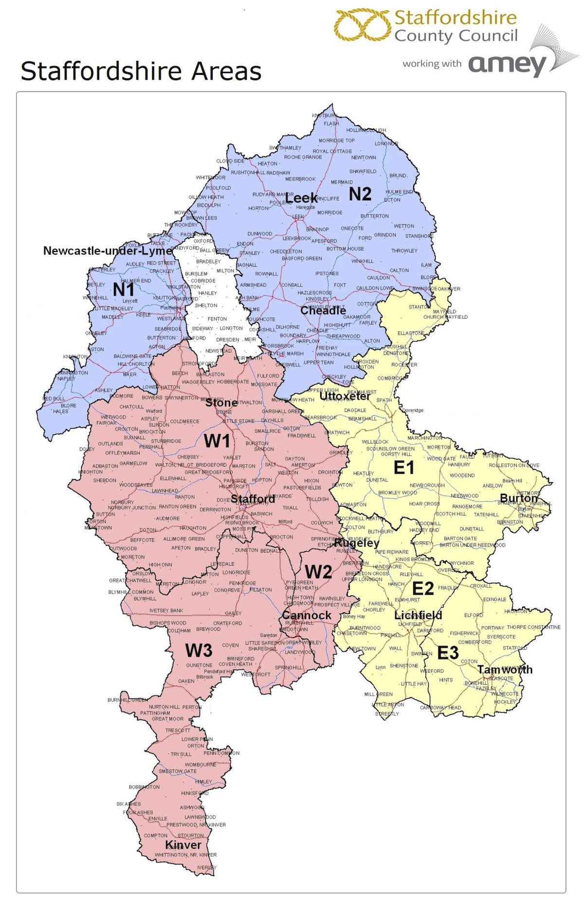
Map of Staffordshire Council Areas
A simple and modern map highlighting the administrative areas covered by Staffordshire County Council. The city of Stoke (in white) is excluded as it is administered by its own separate council.
➤ Download the Staffordshire Council Areas PDF map here.
→ You may also like: The Complete Guide to Cannock Chase Forest
Accommodation Map: Best Places to Stay in Staffordshire
Finding the right accommodation ensures a comfortable base for exploring. Here are our top Cotswolds recommendations to suit all budget ranges:
◉ Luxury: The Ballroom (Lichfield) – an entire modern apartment close to Lichfield Cathedral and Cannock Chase Forest – Superb 9.2☆
◉ Budget: The Upper House (Stoke-on-Trent) – an en-suite family room in this 18th century manor home that Josiah Wedgwood built and gifted his grandson! – Superb 9.0☆
➡️ Psst… how about Glamping in Staffordshire?
For something truly unique, why not stay at one of Staffordshire’s best log cabins with hot tubs?
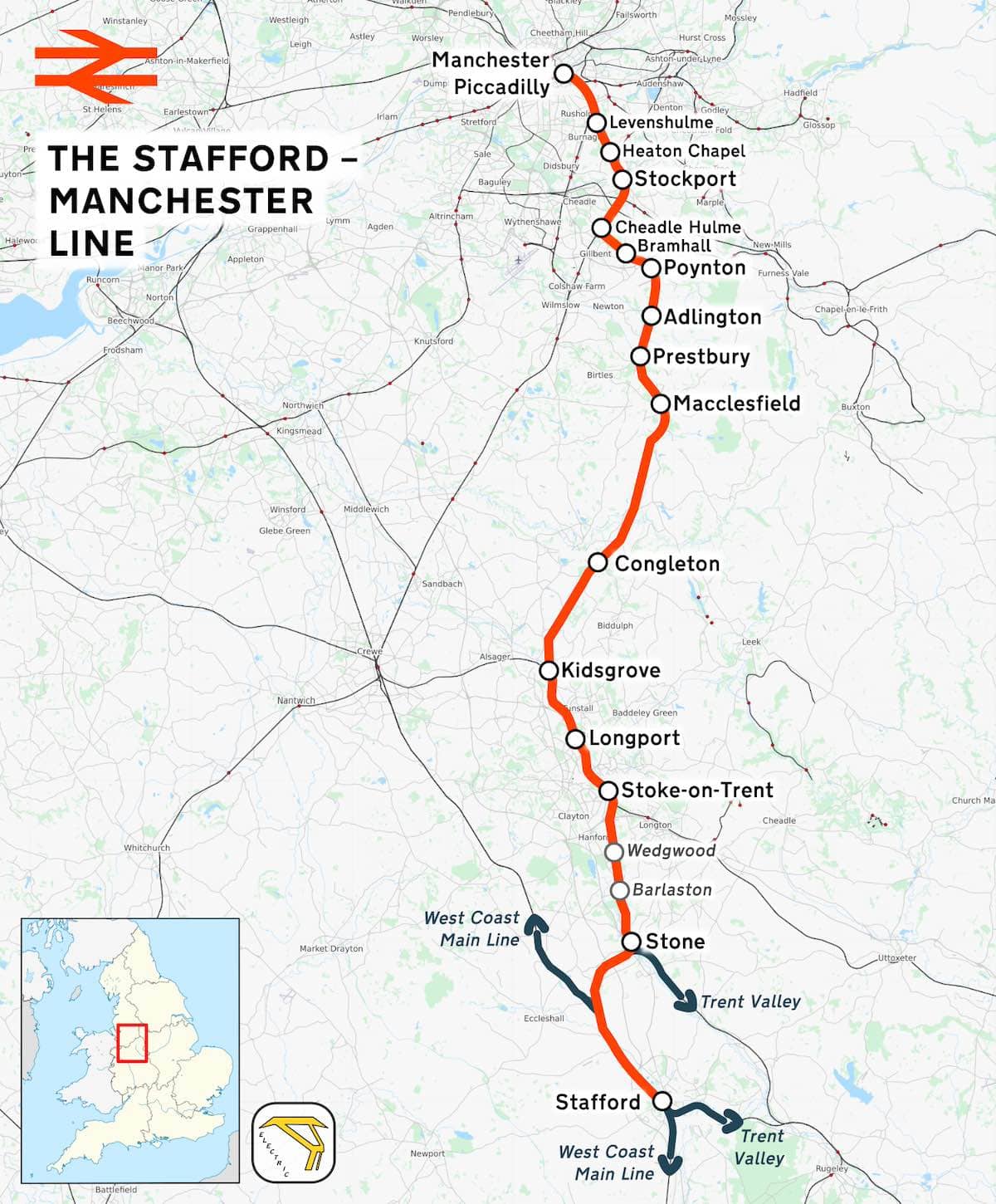
The Stafford-Manchester Line Rail Map
This map shows the main railway route that crosses northern Staffordshire, to Manchester. The direct rail line starts in Stafford and ends at Manchester Picadilly, with changes at stops along the route that take you to Stone, Stoke-on-Trent, Longport, Kidsgrove, Macclesfield, Stockport and more.
➤ Download the Stafford-Manchester Line Rail Map PDF here.
→ Read more: Must-See Royal Market Towns in Staffordshire
Postcode Area Map of Staffordshire
Here is a map outlining the ST (Stoke-on-Trent and Staffordshire) postcode area districts across Staffordshire, including towns like Leek, Newcastle-under-Lyme, and Stafford, with red border and boundary lines.
➤ You can download the ST Postcode Map PDF here.

→ Further reading: Cotswolds Maps (Collection of Free PDFs)
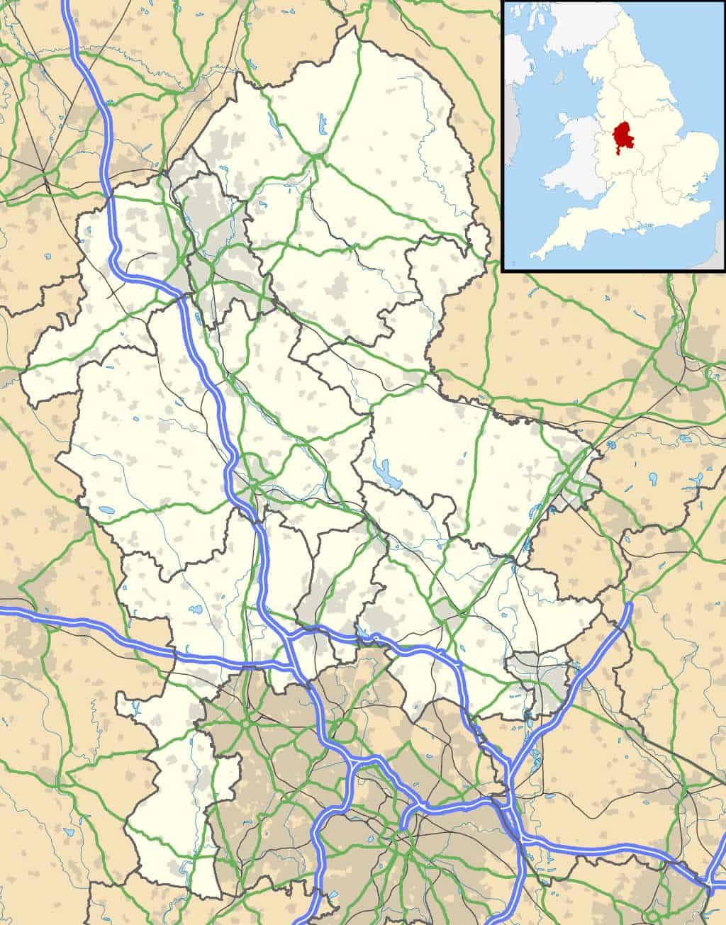
Location Map of Staffordshire in England
A map outlining the county of Staffordshire, England, with motorways in blue, main A roads in green, and urban areas in grey highlighting towns and cities. Another, small map of the UK in the top left corner highlights Staffordshire’s position within the country in red.
➤ You can download the Staffordshire Location Map PDF here.
→ See also: 41+ Curious Facts about Stoke
Staffordshire Locator Map in England
Here we have a map of England with county borders, and Staffordshire county highlighted in dark red.
➤ You can download the Staffordshire Locator Map PDF here.
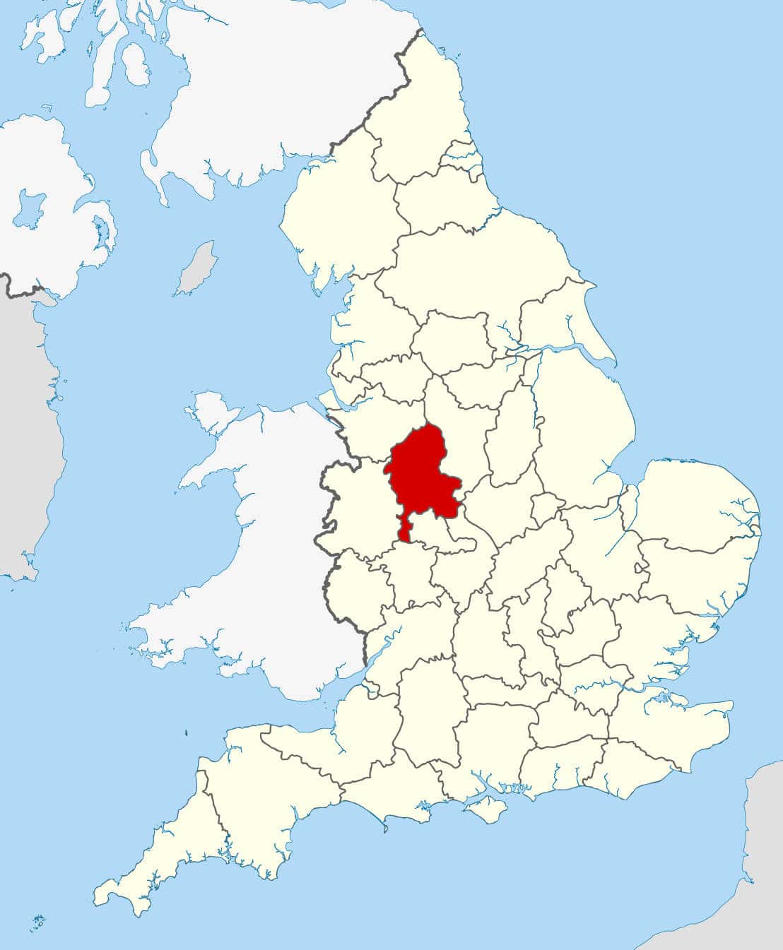
→ Read more: 15 Free Peak District Maps + Guides
Vintage 1832 Map of Staffordshire
Next is an administrative map from 1832, with different shades of green highlighted areas and regions within Staffordshire then known as the “historical hundreds”, with many former names of regions, towns and villages that are no longer in use today.
➤ Download the Vintage Staffordshire 1832 Map PDF here.
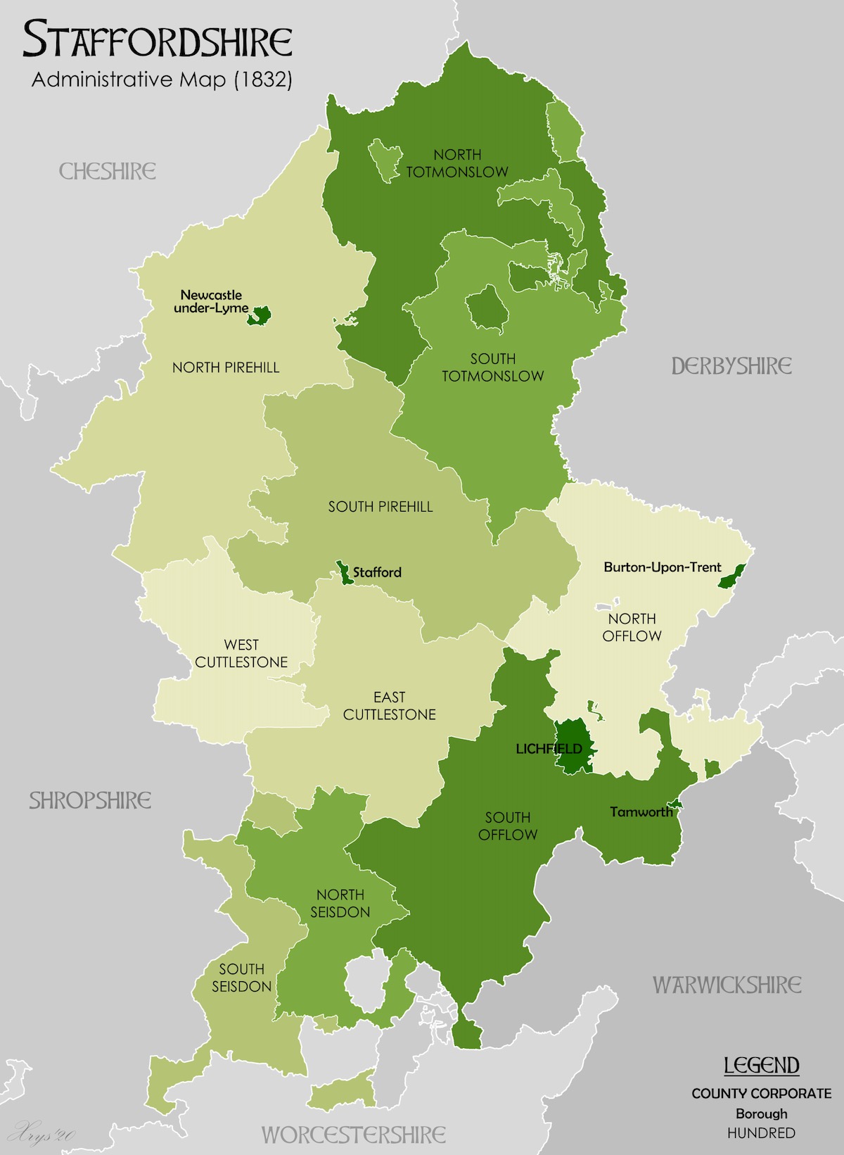
Notice that Stoke-on-Trent, the county’s most populous city, doesn’t exist as it’s a modern federation city of six towns that was established 80 years later.
→ Related: The Wrekin: Shropshire’s Highest Peak (Guide + Maps)
Vintage Staffordia Atlas
A vintage map dated from medieval times, named “Staffordia” – the former, medieval name of Staffordshire. A yellow border outlines the county, geographical images and crests surround the map, while featured in the county map are intricate detailed illustrations of hills, rivers, roads and markers of old place names.
➤ Download the Vintage Staffordia Atlas PDF here.

Related: more West Midlands Maps posts:
Birmingham Maps [+ Travel Guides, Brochures]
Maps of The 6 Towns of Stoke-on-Trent [Free PDFs]
Free PDF Maps of the West Midlands County
Shropshire County Maps (Free Downloads)
Shrewsbury Maps [Free PDF Downloads]
Maps of Warwickshire (Free PDFs)
Free Printable PDF Maps of Coventry
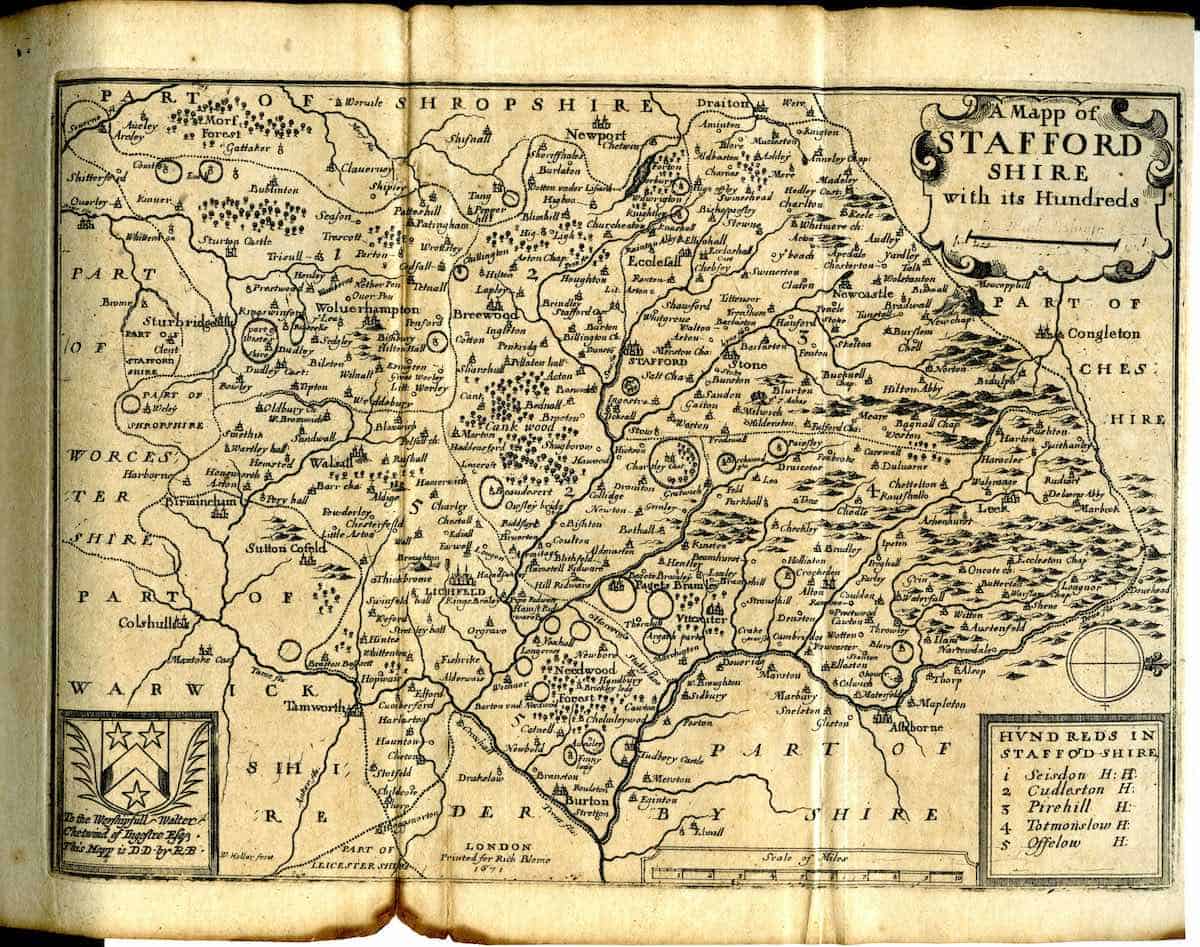
Vintage Map of Staffordshire by Blome, circa 1660s
Vintage map of Staffordshire dating back to the 1660s by cartographer Richard Blome for his Old Maps of England collection. It depicts the ancient county of Staffordshire with its earlier borders including parts of the West Midlands, as well as former place names that no longer exist. The detail in the rivers, old roads and hills is immaculate.
➤ Download the Vintage Staffordshire Blome Map 1660s PDF here.
Satellite view of Staffordshire (Google Maps)
Here is an interactive satellite map of Staffordshire on Google Maps. You can scroll around the map and zoom in to see a 3D view of the towns and villages, along with landmarks, nature spots and attractions that you can click on and discover more information about.
→ Related: Where to Eat in Staffordshire:
Best Restaurants in Stone (Insider’s Guide)
7 Best Restaurants in Cheadle, Staffordshire
Best Restaurants in Leek – My Top Picks
14 Top Places to Eat in Stoke-on-Trent
Best Restaurants in Newcastle: Our 9 Top Picks
Best Afternoon Tea Spots in Staffordshire
General Information about Staffordshire
Area: 1,048 square miles (2,714 km²)
Name origins: Named after its county capital, Stafford, meaning “ford” (river crossing) by a “staithe” (landing place).
Weather: -1°C lowest (winter), 22°C highest (summer)
Population: 876,000 (2022 estimate)
Highest Peak: Cheeks Hill (520m), part of the Roaches in the Pennine uplands.
Largest Lake: Rudyard Lake (168 acres), a magnificent Victorian reservoir.
Unique Features: A county of two halves: the wild moorlands of the Peak District in the north and the industrial Potteries conurbation in the centre.
Hidden gems: England’s Last Real Smithy (Eccleshall), the Ancient Croxden Abbey ruins, the Canal Tunnels of the Potteries.
Famous Residents: Robbie Williams (singer, from Stoke-on-Trent), Arnold Bennett (author, from Hanley), Slash (Guns N’ Roses guitarist, raised in Stoke-on-Trent), Captain Edward Smith (Captain of the RMS Titanic, from Hanley).
Final Tips for Your Staffordshire Trip
✅ Purchase a laminated OS Explorer Map if you plan serious walking – the weather can change quickly in this landscape.
✅ The OS Maps App (50% off here) provides excellent real-time directions across all trails with the location of most popular and hidden gem attractions
✅ Respect the wildlife – stick to marked trails and rely on the Countryside Code.
✅ Consider visiting in shoulder seasons (April-May or September-October) to avoid crowds.
✅ Combine your trip with visits to nearby regions like Shropshire or the Peak District for extended exploration.
→ Read More: Staffordshire articles
Stone, Staffordshire: History, Facts & Things to Do (Guide)
Leek & Peak District, Staffordshire [Complete Guide]
26 Top Family-Friendly Activities in Stoke, Staffordshire
14 Best Real-Ale Pubs in Stoke (An Insider’s Guide)
The Finest Pubs in Leek, Staffordshire